Section 04
Site
Appendix F-1, page 56
The Site section provides information about the characteristics of the parcel(s) such as size, property access, site influences, utilities, and property restrictions. These details are key to providing an understanding of the property and the influences that define and affect the location. This section provides space for additional commentary, exhibits, and information about any apparent defects, damages, or deficiencies related to the site. The Site section always displays.
General Information#
Site Size and Parcels#

Site Size and Parcels
| Applies To | Report Field ID | Report Label | When to Include | Allowable Answers / Format | Definition / Additional Guidance |
|---|---|---|---|---|---|
| All | 4.000 | Total Site Size | Required if Site Owned in Common is No | Number of acres, square feet, hectares, or square meters | The total area of the site, including all parcels. - For area less than 1 acre, use square feet in whole numbers (e.g., 27,840 sq. ft.). - For area that is 1 acre or more, use acres to 2 decimals (e.g., 1.25 acres). - If using the metric system, for area less than 1 hectare, use square meters in whole numbers (e.g., 7,500 sq. m.). - If using the metric system, for area that is 1 hectare or more, use hectares to 2 decimals (e.g., 1.25 hectares). Note: - If there is more than one parcel, the Total Site Size may not exactly match the sum of all Parcel Sizes (4.007) due to rounding differences for individual parcels. - If new construction and providing an estimate, provide an explanation and describe in Site Commentary (4.116). |
| FHA/VA/USDA | 4.001 | Dimensions | May be provided for FHA, USDA, and VA appraisals if Site Owned in Common is No | Free-form | The dimensions of the site such as its width and depth. Note: Must be consistent with other forms of measurement in the report. Reference the appropriate government agency appraisal guidelines for more information. |
| All | 4.002 | Number of Parcels | Required if Site Owned in Common is No | Number | The total number of parcels that comprise the subject property. |
| All | 4.003 | Contiguous | Required if Number of Parcels is more than 1 | Yes | No | Parcels Contiguous Indicates whether two or more parcels share at least one common boundary. - Yes (2 or more parcels share a common boundary). - No (the parcels are divided). |
| All | 4.004 | Elements Dividing Parcels | Required if Parcels Contiguous is No | Choose one or more allowable answers from the Definition / Additional Guidance column | The elements that separate non-contiguous parcels. - Body of Water - Other Parcel - Road - Other (Describe) |
Rows marked
FHA/VA/USDAare shaded green in the PDF: they apply only to FHA, VA, or USDA appraisals.
Information for Each Parcel#

Site: Information for each Parcel
| Report Field ID | Report Label | When to Include | Allowable Answers / Format | Definition / Additional Guidance |
|---|---|---|---|---|
| 4.005 | Assessor Parcel Number (APN) | Required for each parcel if the property is not in a cooperative, or if applicable when the property is in a condop. | Free-form | A number assigned to parcels of real property by the local jurisdiction for purposes of identification, record-keeping, and taxation. Note: If the APN is not yet assigned, enter "Not Assigned". |
| 4.006 | APN Description | Required for each parcel if the property is not in a cooperative, or if applicable when the property is in a condop. | Choose an allowable answer from table (APN Description) | A description of the use of the land. An APN is required for each parcel that is included in the valuation when one has been assigned by the local taxing authority. - Land with Dwelling - Condominium Unit - Land with Improvement - Vacant Land - Boat Slip - Parking - Storage - Other (Describe) |
| Not on Report | This is an appraiser input that does not display | If available for each parcel | Free-form | Alternative Property Identifier: A proprietary value used to identify parcels of real property. |
| 4.007 | Parcel Size | Required for each parcel if Site Owned in Common is No and APN Description is Land with Dwelling, Land with Improvement, or Vacant Land | Number of acres, square feet, hectares, or square meters | Parcel Size: The area of the individual parcel. - For area less than 1 acre, use square feet in whole numbers (e.g., 27,840 sq. ft.). - For area that is 1 acre or more, use acres to 2 decimals (e.g., 1.25 acres). - If using the metric system, for area less than 1 hectare, use square meters in whole numbers (e.g., 7,500 sq. m.). - If using the metric system, for area that is 1 hectare or more, use hectares to 2 decimals (e.g., 1.25 hectares). |
APN Description (Choose all that apply)
| Allowable Answer | Definition / Additional Guidance |
|---|---|
| Land with Dwelling | A parcel containing one or more living units. Examples: - Dwelling on a single lot - Dwelling on multiple lots with independent APNs |
| Condominium Unit | A living unit in a condominium project. For use when the property is in a condominium and Site Owned in Common (3.015) is Yes. |
| Land with Improvement | Land with one or more structures that do not contain living units (e.g., shed, barn). For use when the additional parcel does not contain a dwelling and has its own separate APN. |
| Vacant Land | Land containing no structures or dwellings. For use when the additional parcel is vacant land and has its own separate APN. May include utilities to the site. |
| Boat Slip | A privately owned docking point for boats or other watercraft. For use when the boat slip is a separate parcel. |
| Parking | An area specifically designed for vehicle storage. For use when the parking is a separate parcel. |
| Storage | A room or area designed to secure personal belongings. For use when the storage is a separate parcel. |
| Other (Describe) | Select Other to enter an answer that is not in the above list. |
Zoning#
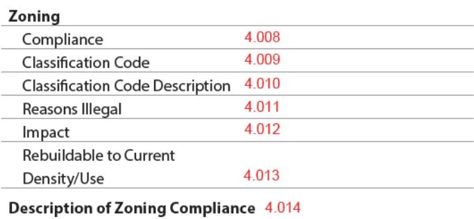
Site: Zoning
| Applies To | Report Field ID | Report Label | When to Include | Allowable Answers / Format | Definition / Additional Guidance |
|---|---|---|---|---|---|
| All | 4.008 | Compliance | Always required | Choose an allowable answer from Definition / Additional Guidance column | Zoning Compliance: The level of compliance of the site or improvements with zoning regulations. - Illegal - Legal - Legal Nonconforming (A permissible exception to current zoning ordinances where the property was legally conforming when established but no longer conforms with current zoning) - No Zoning (see also Property Restrictions (4.050-4.053), if applicable) |
| All | 4.009 | Classification Code | Required for all Zoning Compliance responses except No Zoning | Free-form | Zoning Classification Code as defined by the local governing authority (e.g., R1). |
| All | 4.010 | Classification Code Description | Required for all Zoning Compliance responses except No Zoning | Free-form | Descriptive text that explains the details of the Classification Code as used and defined by the local governing authority. Examples: - Residential single-family dwellings on 1 acre lots - Mixed use structures and low-rise multifamily units in the defined Central Business District (CBD) |
| All | 4.011 | Reasons Illegal | Required if Zoning Compliance is Illegal | Choose one or more allowable answers from table (Reasons Illegal) | The reason(s) the site does not comply with zoning regulations. - Accessory Dwelling Unit - Development Standards - Excessive Units - Lot Size - Manufactured Home - Other (Describe) |
| All | 4.012 | Impact | Required if Zoning Compliance is not Legal | Adverse, Beneficial, or Neutral | |
| FHA/VA/USDA | 4.013 | Rebuildable to Current Density / Use | Required for FHA, USDA, and VA appraisals when Zoning Compliance is Legal Nonconforming | Yes | No | Indicates whether the building code or zoning regulations allow the property to be rebuilt to the current density and use if current improvements are destroyed. |
| All | 4.014 | Description of Zoning Compliance | Required if Zoning Compliance is not Legal, or if relevant | Free-form | Description could include information pertinent to zoning compliance that is not captured in the discrete data, or additional details to support the discrete data that is provided. |
Rows marked
FHA/VA/USDAare shaded green in the PDF: they apply only to FHA, VA, or USDA appraisals.
Site: Zoning - Reasons Illegal (Choose all that apply)
| Allowable Answer | Definition / Additional Guidance |
|---|---|
| Accessory Dwelling Unit | Accessory dwelling units are not allowed on the site. |
| Development Standards | Site is not compliant with development regulations (e.g., a dwelling with a building footprint that exceeds the allowable setback lines or size restrictions). |
| Excessive Units | The property exceeds the allowable density established by the local zoning authority (e.g., a two-to-four unit property in an area that permits only one-unit properties in the zoning regulations). |
| Lot Size | Site size does not meet standards established by local zoning authority. |
| Manufactured Home | Manufactured homes are not allowed on the site. |
| Other (Describe) | Select Other to enter an answer that is not in the above list. |
Property Use#
This subsection displays when Site Owned in Common (3.015) is No.
- When Site Owned in Common is Yes, non-residential use such as live/work space in the living unit is reported in the Unit Interior section (10.026-10.028).
- Commercial space in condominium, cooperative, or condop project buildings is reported in the Project Information section (18.069).
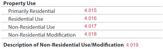
Site: Property Use
| Applies To | Report Field ID | Report Label | When to Include | Allowable Answers / Format | Definition / Additional Guidance |
|---|---|---|---|---|---|
| All | 4.017 | Non-Residential Use | Required if Site Owned in Common is No | Yes | No | Non-Residential Uses on Property: Indicates whether the property includes space set aside to operate a business. When analyzing this for a condominium or cooperative (such as a site condo), only include areas that are part of the subject unit and not the entire project. Project analysis is handled in the Project Information section. Notes: - If Yes, the Non-Residential Property Use row displays in the Site Features Table (4.043-4.046), and additional information must be provided. - If No, "None" displays. |
| All | 4.015 | Primarily Residential | Required if Non-Residential Uses on Property is Yes | Yes | No | Indicates whether the property's use is primarily residential when the property includes non-residential space set aside to operate a business. Although income should be considered, it may not be the sole determining factor if the property is primarily residential. |
| FHA/VA/USDA | 4.016 | Residential Use | Required for FHA, USDA, and VA appraisals if Non-Residential Uses on Property is Yes | Percent | Percent of Residential Use Reference the appropriate government agency appraisal guidelines for more information. |
| All | 4.017 | Non-Residential Use | Required if Non-Residential Uses on Property is Yes | Choose one or more allowable answers from the Definition / Additional Guidance column | The type(s) of non-residential use observed on the property. - Agricultural - Commercial (e.g., retail, day care, elder care, beauty or barber shop, doctor's office) - Industrial - Other (Describe) Notes: - Also displays in the Site Features Table (4.044). - Photo(s) of non-residential use must be provided, which display in Site Exhibits with the caption "Non-Residential Use". An additional caption including the type of non-residential use, location, and any other descriptive information as appropriate may be provided. |
| All | 4.018 | Non-Residential Modification | Required if Non-Residential Uses on Property is Yes | Yes | No | |
| All | 4.019 | Description of Non-Residential Use / Modification | Required if Non-Residential Uses on Property is Yes | Free-form | Commentary on the nature of the non-residential use and / or modifications, including the extent of the changes and whether they have an adverse impact on marketability as a residential property. |
Rows marked
FHA/VA/USDAare shaded green in the PDF: they apply only to FHA, VA, or USDA appraisals.
Property Access#
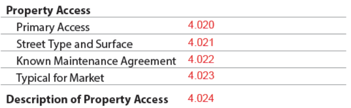
Site: Property Access
| Report Field ID | Report Label | When to Include | Allowable Answers / Format | Definition / Additional Guidance |
|---|---|---|---|---|
| 4.020 | Primary Access | Always required | Choose an allowable answer from table (Primary Access to Property) | Primary Access to Property: The primary ingress and egress method to the property. - Pedestrian Only Access - Private Airstrip - Private Street - Public Street - Waterway - Other (Describe) Notes: - For condominiums, cooperatives, and condops, reference published guidelines by the GSEs, government agencies, or other identified secondary market participants for specific guidance. - Photo(s) of the property access must be provided, which display in Site Exhibits with the caption "Property Access (Street Scene)". An additional caption may be provided to further identify the photo. |
| 4.021 | Street Type and Surface | Required for each street if Primary Access to Property is Public Street, or Private Street | Choose one or more allowable answers from table (Street Type) | Street(s) Used to Access Property: The means of direct access and exit for all roads to and from the property. - Alley - Arterial Street - Collector Street - Cul-de-sac - Dead End - Local Road - Rural Road - Other (Describe) Note: For condominiums, cooperatives, and condops, reference published guidelines by the GSEs, government agencies, or other identified secondary market participants for specific guidance. |
| 4.021 | Street Type and Surface | Required for each street if Primary Access to Property is Public Street, or Private Street | Choose an allowable answer from the Definition / Additional Guidance column | Street Surface Material - Asphalt - Brick - Concrete - Cobblestone - Dirt - Gravel - Other (Describe) Note: If the street is made of multiple materials, choose the predominant one. |
| 4.022 | Known Maintenance Agreement | Required if Primary Access to Property is Private Street | Yes | No | Indicates whether there is an enforceable maintenance agreement for a private street used to access the property that is known to the appraiser. Notes: - Select Yes if the private street is maintained by the HOA or PUD. - An image of the maintenance agreement may be provided, which displays in Site Exhibits. A caption may be provided to identify the image as being of a maintenance agreement, and any other descriptive information as appropriate. |
| 4.023 | Typical for Market | Always required | Yes | No | Access to Property Typical for the Market: Indicates whether the property access is common in the market location. |
| 4.024 | Description of Property Access | Required if Access to Property Typical for the Market is No, or as needed | Free-form | Description of the access to the property including why it is not typical for the market. Additional commentary to include details and other information may be provided. |
Primary Access to Property (Choose one)
| Allowable Answer | Definition / Additional Guidance |
|---|---|
| Pedestrian Only Access | Indicates the property is landlocked and can only be accessed by foot (e.g., walking, hiking) and cannot be accessed by any other method. An easement is typically required to access the property. Note: Choose this answer for situations in which there is a street giving access to the subject property that has been converted to pedestrian-only access and is the only access. |
| Private Airstrip | Note: Do not include airstrips that serve a project or community. These are reported in Common Amenities / Services (18.012). |
| Private Street | Note: Do not choose this answer for pedestrian-only streets. |
| Public Street | Note: Do not choose this answer for pedestrian-only streets. |
| Waterway | |
| Other (Describe) | Select Other to enter an answer that is not in the above list. |
Street Type (Choose all that apply)
| Allowable Answer | Definition / Additional Guidance |
|---|---|
| Alley | A typically narrow passageway between buildings or residences that is designed to provide access to the property but not meant for use as a local road. |
| Arterial Street | A high-capacity road primarily designed to provide routes from city to city; features divided lanes and high to moderate rates of speed, limited and controlled pedestrian access (e.g., state or county highway). |
| Collector Street | A moderate-capacity road designed to link to arterial roads and collect traffic from local roads; may feature divided lanes, moderate rates of speed, and controlled pedestrian access. |
| Cul-de-sac | A low-capacity road designed as a non-through street that ends in a circle typically used for vehicle turn around; features a low rate of speed and unregulated pedestrian access. |
| Dead End | A low-capacity road or series of roads that end abruptly with no specified area for vehicle turn around and only one means of entry and exit; features a low rate of speed and unregulated pedestrian access (e.g., non-through street). |
| Local Road | A moderate- to low-capacity road primarily designed to provide direct access to individual residential properties; typically features single lane, low rates of speed and unregulated pedestrian access (e.g., neighborhood or residential road). |
| Rural Road | A low-capacity road primarily designed to provide direct access to agricultural properties and larger acreage residential properties; typically present in areas of low population density with low rates of speed and unregulated pedestrian access (e.g., county road). |
| Other (Describe) | Select Other to enter an answer that is not in the above list. |
Site Influence#
The appraiser must fully consider all of the influences that impact the value and marketability of a property's site and location. These may be onsite or offsite, and sometimes may not be visible from the property or may even be located some distance away.
The appearance of the Site Influence table varies based on the details of the property being appraised.

**Site: Site Influences**
| Report Field ID | Report Label | When to Include | Allowable Answers / Format | Definition / Additional Guidance |
|---|---|---|---|---|
| 4.025 | Influence | Always required | Choose one or more allowable answers from table (Site Influence) | Site Influence: Specifies an influence on the property. Note: Photos or images for each site influence may be provided, which display in Site Exhibits with the caption "Site Influence". An additional caption may be provided, including the site influence type and any other descriptive information as appropriate. |
| 4.030 | Site Influence Commentary | If relevant | Free-form | Overall commentary for all site influences. |
Site Influence (Choose all that apply)
| Allowable Answer | Definition / Additional Guidance |
|---|---|
| Agricultural | |
| Airport | A designated area where aircraft take off and land. Note: Airport influences can extend to flight paths where landing and take-off patterns may create higher noise levels. Choose this answer when reporting on these types of influences. |
| Body of Water | Choose this answer if there are one or more bodies of water that influence the site. Note: If applicable, see also the Water Frontage with Private Access subsection (4.031-4.038). |
| Busy Roadway | |
| Commercial Area | An area intended to produce income (e.g., office buildings, retail buildings, hospitality). |
| Golf Course | |
| Green Space | An area of protected or conserved land or water on which development is indefinitely set aside. |
| High Density Residential | A densely populated residential area. |
| High Pressure Gas Line | A distribution system with lines in which the gas pressure in the main is higher than the pressure provided to the customer. |
| Historic District | A district designated to be of historical significance by a recognized authority. |
| Industrial Area | An area intended for the production of manufactured goods (e.g., factories). |
| Local Distribution Line | Electric lines that commonly supply power to residential housing developments, similar facilities and individual properties. |
| Oil or Gas Well | |
| Overhead Electric Power Transmission Line | Electric lines that supply power from power generation stations to local distribution lines. |
| Park | |
| Public Transportation Hub | A location where public transportation can be accessed (e.g., bus transfer station, metro station). |
| Rail Line | The rail line used by commercial or commuter trains (e.g., railroad tracks, metro tracks). |
| Residential | |
| School | |
| Stormwater Retention | An area designed to hold or retain stormwaters on a permanent basis. |
| Other (Describe) | Select Other to enter an answer that is not in the above list. Example: Place of Worship |
Information for each Site Influence#
Site: Information for each Site Influence
| Applies To | Report Field ID | Report Label | When to Include | Allowable Answers / Format | Definition / Additional Guidance |
|---|---|---|---|---|---|
| All | 4.026 | Proximity | Required for each site influence | Choose an allowable answer from table (Proximity) | Proximity of the site influence or body of water to the property. - Bordering - Offsite - Onsite |
| All | 4.027 | Detail | Required if Site Influence is Body of Water | Choose one or more allowable answers from the Definition / Additional Guidance column | Body of Water Type - Bay - Canal - Cove - Creek - Gulf - Lake - Marsh - Ocean - Pond - Reservoir - River - Sound - Other (Describe) |
| FHA/VA/USDA | 4.027 | Detail | Required for FHA, USDA, and VA appraisals when Site Influence is Airport | Choose an allowable answer from table (Special Airport Hazard Zone) | Special Airport Hazard Zone: Areas mapped as special airport hazard zones at the ends of runways where aircraft accidents are most likely to occur. - None (Not in a Special Airport Hazard Zone) - Civil Airport Runway Clear Zone - Military Airport Accident Potential Zone 1 - Military Airport Clear Zone - Other (Describe) Reference the appropriate government agency appraisal guidelines for more information. |
| FHA/VA/USDA | 4.027 | Detail | Required for FHA, USDA, and VA appraisals when Site Influence is Local Distribution Line, Overhead Electric Power Transmission Line, or High Pressure Gas Line | Yes | No | Meets Policy Requirements: Indicates whether the site influence meets applicable policy requirements. - Yes (Meets Policy Requirements) - No (Does Not Meet Policy Requirements) Reference the appropriate government agency appraisal guidelines for more information. |
| All | 4.028 | Impact | Required for each Site Influence | Adverse, Beneficial, or Neutral | |
| All | 4.029 | Comment | Required for each Site Influence if Impact is Adverse or Beneficial, or if Meets Policy Requirements is No, or as needed | Free-form | When Adverse or Beneficial, describe the impact to value and / or marketability. Additional commentary may be provided to include details and other information. |
Rows marked
FHA/VA/USDAare shaded green in the PDF: they apply only to FHA, VA, or USDA appraisals.
Proximity (Choose one for each Site Influence or Environmental Condition)
| Allowable Answer | Definition / Additional Guidance |
|---|---|
| Bordering | An influence located on or coming from a site that directly abuts the subject site. |
| Offsite | An influence located on or coming from a site that is not the subject site nor directly abuts the subject site. |
| Onsite | An influence located on or coming directly from the subject site. |
Special Airport Hazard Zone (Choose one)
| Applies To | Allowable Answer | Definition / Additional Guidance |
|---|---|---|
| FHA/VA/USDA | None (Not in a Special Airport Hazard Zone) | Select this answer if the property is not in a Special Airport Hazard Zone. |
| FHA/VA/USDA | Civil Airport Runway Clear Zone | Areas immediately beyond the ends of runways for civil airports as established by Federal Aviation Administration for the purpose of enhancing protection of people and property on the ground in the event an aircraft lands or crashes beyond the runway end. |
| FHA/VA/USDA | Military Airport Accident Potential Zone 1 | Areas beyond the Clear Zone for military airfields established by the United States Department of Defense as a planning tool for local planning agencies. Accident Potential Zones are areas where aircraft mishaps are most likely to occur near the airfields. |
| FHA/VA/USDA | Military Airport Clear Zone | Areas immediately beyond the ends of runways for military airfields established by the United States Department of Defense. |
| FHA/VA/USDA | Other (Describe) | Select Other to enter an answer that is not in the above list. |
Rows marked
FHA/VA/USDAare shaded green in the PDF: they apply only to FHA, VA, or USDA appraisals.
Apparent Environmental Conditions#
The appraiser must fully consider any apparent environmental conditions that impact the value and marketability of the property. Environmental conditions may be onsite or offsite, may not be visible on or from the property, or may even be located some distance away.
There is one Apparent Environmental Condition row in the Site Influence table for each Apparent Environmental Condition. If there are no environmental conditions, this row does not display.
**Site: Site Influence - Apparent Environmental Conditions**
| Report Field ID | Report Label | When to Include | Allowable Answers / Format | Definition / Additional Guidance |
|---|---|---|---|---|
| 4.027 | Detail | Always required | Choose one or more allowable answers from table (Apparent Environmental Condition) | Apparent Environmental Condition: A type of environmental condition identified during the analysis of a lot or structure. - None - Hazardous Above Ground Storage Tank - Hazardous Substances - Landfill - Radon - Slush Pit - Soil Contamination - Superfund Site - Underground Storage Tank - Water Contamination - Other (Describe) |
| 4.026 | Proximity | Required for each identified Apparent Environmental Condition | Choose an allowable answer from table (Proximity) | Proximity of the environmental condition to the property. - Bordering - Offsite - Onsite |
| 4.026 | Proximity | Required if Proximity is Bordering or Offsite | Number of feet, meters, miles or kilometers | Distance from Property: The approximate distance from the property to the environmental condition, as measured from the closest point of the apparent environmental condition to the subject property line. Reference published guidelines by the GSEs, government agencies, or other identified secondary market participants for specific guidance. |
| 4.028 | Impact | Required for each identified Apparent Environmental Condition | Adverse, Beneficial, or Neutral | |
| 4.029 | Comment | Required for each identified Apparent Environmental Condition | Free-form | Commentary on the nature of the environmental condition, and its impact to value and / or marketability. |
Apparent Environmental Condition (Choose all that apply)
| Allowable Answer | Definition / Additional Guidance |
|---|---|
| None | Select this answer if there are no apparent environmental conditions that influence the property, and the Apparent Environmental Condition row does not display. |
| Hazardous Above Ground Storage Tank | Stationary storage tank above the surface grade with capacity of 1000 gallons or more of flammable or explosive material. |
| Hazardous Substances | Any material that may be harmful to humans, the property, and / or the environment. |
| Landfill | An area of land that is built up from deposits of solid refuse in layers covered by soil. |
| Radon | A heavy radioactive gaseous element formed by the decay of radium. |
| Slush Pit | Earthen pit or basin excavated next to drilling rigs that are used for the collection and disposal of drilling muds and well cuttings. |
| Soil Contamination | The presence of chemicals or other alterations to the natural soil environment. |
| Superfund Site | A site established by the Federal Comprehensive Environmental Response, Compensation, and Liability Act of 1980 and administered by the Environmental Protection Agency, enabling it to investigate and clean up sites contaminated with hazardous substances. |
| Underground Storage Tank | A storage tank that is below the surface grade. |
| Water Contamination | Water that contains any foreign substance that can be harmful to humans, the property, and / or the environment (e.g., lead, arsenic). |
| Other (Describe) | Select Other to enter an answer that is not in the above list. |
Water Frontage with Private Access#
The appraiser must indicate whether the property has private access to each Body of Water Type that was indicated in the Site Influences subsection above. Private access is intended to mean that the access is either owned by the subject property or exclusively granted to the subject property through easement or right.
This section is not intended for public or community waterfront access used as an amenity in projects, communities, or other housing developments. Instances where community waterfront access is included as an amenity in mandatory HOA fees must be reported in Common Amenities / Services (18.012) in the Project Information section.
If the property does not have private access to any body of water, this subsection does not display.
Site: Water Frontage
| Report Field ID | Report Label | When to Include | Allowable Answers / Format | Definition / Additional Guidance |
|---|---|---|---|---|
| Not on Report | This is an appraiser input that does not display | Always required for each Body of Water Type | Yes | No | Property Has Private Access Rights to the Body of Water: Indicates whether the property has private access to the associated body of water. This represents private access from the property only, either through a community buffer or exclusive to the property. Do not select Yes to report on public, community, or project waterfront access and amenities. |
For All Private Water Frontage on the Property#
This subsection includes information about all private water frontage on the property.

Site: Information for all Private Water Frontage on the Property
| Report Field ID | Report Label | When to Include | Allowable Answers / Format | Definition / Additional Guidance |
|---|---|---|---|---|
| 4.031 | Total Linear Measurement | Required if Property Has Private Access Rights to the Body of Water is Yes for one or more bodies of water | Number of feet or meters | Water Frontage Total Length: The approximate total linear measurement of all waterfront with private access, measured in front footage. |
| 4.032 | Permanent Waterfront Feature | Required if Property Has Private Access Rights to the Body of Water is Yes for one or more bodies of water | Choose one or more allowable answers from table (Permanent Waterfront Feature) | A permanent feature in or alongside a body of water. - None - Beach - Boat Lift - Boat Ramp - Boat Slip - Dock - Pier - Riprap - Seawall or Bulkhead - Other (Describe) Notes: - If there are multiple permanent waterfront features and bodies of water, provide further details in Water Frontage Commentary (4.038). - Photos or images for the indicated permanent waterfront feature may be provided, which display in Site Exhibits with the caption "Permanent Waterfront Feature". An additional caption may be provided, including the waterfront feature type(s) and any other descriptive information as appropriate. |
| 4.033 | Right to Build | Required if Permanent Waterfront Feature is None | Yes | No | Right to Build Waterfront Features When there are no waterfront features on the property (Permanent Waterfront Feature is None), indicate whether the property has the right to improve the shoreline or build waterfront features. |
Permanent Waterfront Feature (Choose all that apply)
| Allowable Answer | Definition / Additional Guidance |
|---|---|
| None | There are no waterfront features on the property. |
| Beach | A strip of land separating a body of water from inland areas, typically used for recreation or leisure purposes. |
| Boat Lift | A machine for raising and lowering watercraft to and from the water. |
| Boat Ramp | A form of access point, leading to a body of water, for boats or other watercraft. |
| Boat Slip | A docking point for boats or other watercraft. |
| Dock | A platform leading out from shore into a body of water that is not attached to pillars or girders. Can be permanently installed, or temporary to allow for removal due to seasonality. Note: Docks that are temporary or not permanently installed are considered personal property and are not reported here. |
| Pier | A permanent structure leading out from shore into a body of water, typically made of concrete, steel, or treated timbers and supported on pillars or girders. |
| Riprap | Rock or other material set in place to protect shorelines (e.g., shot rock, rock armor, or rubble). |
| Seawall or Bulkhead | A wall or structure designed to protect shorelines from wave loads and / or to retain soils and prevent erosion. Select this answer only when it is privately owned and maintained, and part of the real estate being valued. |
| Other (Describe) | Select Other to enter an answer that is not in the above list. Note: Boathouses must be reported in the Outbuilding section and are not reported here. |
For each Body of Water with Private Access#
Indicate which bodies of water from above (Body of Water Type (4.027)) have private access from the property, either through a community buffer or exclusive to the property. If there are multiple bodies of water with private access, each displays in a separate row in the Water Frontage with Private Access table.

Site: Information for Each Body of Water with Private Access
| Report Field ID | Report Label | When to Include | Allowable Answers / Format | Definition / Additional Guidance |
|---|---|---|---|---|
| 4.034 | Frontage | If applicable | Choose one or more allowable answers from the Definition / Additional Guidance column | Body of Water Type - Bay - Canal - Cove - Creek - Gulf - Lake - Marsh - Ocean - Pond - Reservoir - River - Sound - Other (Describe) Notes: - Body of Water Type redisplays from 4.027. - Photos or images for all water frontage with private access must be provided, which display in Site Exhibits with the caption "Water Frontage". An additional caption may be provided, including the water frontage type(s) and any other descriptive information as appropriate. |
| 4.035 | Name | If relevant | Free-form | Body of Water Name |
| 4.036 | Waterfront Access Rights | Required for each body of water where Property Has Private Access Rights to the Body of Water is Yes | Choose an allowable answer from table (Waterfront Access Rights) | Type of access the subject property has to the waterfront. - By Permit - Deeded Access - Privately Owned - Other (Describe) |
| 4.037 | Access Depth | Required for each body of water where Property Has Private Access Rights to the Body of Water is Yes | Choose an allowable answer from table (Access Depth) | Classifies the water depth for the purpose of watercraft access. - Deep Water - Non-Navigable - Shallow Water - Other (Describe) Note: Water depth should be approximated considering typical and feasible water depths, whether by dock, pier, or shoreline. |
Waterfront Access Rights (Choose one for each Body of Water with Private Access)
| Allowable Answer | Definition / Additional Guidance |
|---|---|
| By Permit | Temporary permissible use of the waterfront access granted by a recognized authority. |
| Deeded Access | Legally permissible use of the waterfront access written in the deed. |
| Privately Owned | Waterfront access as granted through private ownership of the water frontage. |
| Other (Describe) | Select Other to enter an answer that is not in the above list. |
Access Depth (Choose one for each Body of Water with Private Access)
| Allowable Answer | Definition / Additional Guidance |
|---|---|
| Deep Water | Can handle larger recreational motorboats, sailboats and watercraft with deep hulls, berths, or keels (typically depths of more than 4 feet). |
| Non-Navigable | Water is not suitable for standard motorboats or sailboats with deep keels (typically depths of less than 2 feet). |
| Shallow Water | Can handle watercraft with only a shallow hull, no berth or keel (typically depths of 2 to 4 feet). |
| Other (Describe) | Select Other to enter an answer that is not in the above list. |
Note: For Access Depth, in areas where tides impact the ability to store/use watercraft, a common practice is to reference the Mean Low Water (MLW) depth. This information can often be sourced from local Realtors/MLS listings.
Water Frontage Commentary#
Site: Information for Each Body of Water with Private Access
| Report Field ID | Report Label | When to Include | Allowable Answers / Format | Definition / Additional Guidance |
|---|---|---|---|---|
| 4.038 | Water Frontage Commentary | If relevant | Free-form | Overall commentary for all water frontage, which could include information that is not captured in the discrete data, or additional details to support the discrete data that is provided. |
View and Impact to Value / Marketability#
A key component of a property's location is the view. This subsection contains information about the views associated with the subject property, the range and breadth of those views, and the overall impact the views have on the subject's value and marketability.

Site: View and Impact to Value / Marketability
| Report Field ID | Report Label | When to Include | Allowable Answers / Format | Definition / Additional Guidance |
|---|---|---|---|---|
| 4.039 | View | Always required | Choose one or more allowable answers from the Definition / Additional Guidance column | The specific view types as observed for valuation purposes that may affect market value. - Bay - Canal - City Street - Commercial - Cove - Creek - Golf Course - Gulf - High Density Residential - Highway - Industrial - Lake - Marsh - Mountain - Ocean - Park - Parking Lot - Pastoral - Pond - Reservoir - Residential - River - School - Skyline - Sound - Traffic Wall Barriers - Valley - Woods - Other (Describe) Notes: - Views must be reported and analyzed based on what is readily visible from the property dwelling or unit(s). For high-rise, mid-rise and low-rise properties, the view is reported at the unit level. - Photo(s) must be provided of all views that impact value or marketability, which display in Site Exhibits with the caption "View". An additional caption may be provided, including the view type and any other descriptive information as appropriate. |
| 4.039 | View (Primary) | Always required for each view | Yes | No | Indicates whether the view is the primary view. - Select Yes for the view with most impact, and if there is more than one view, "(Primary)" displays next to the view. |
| 4.040 | Range of View | Always required for each view | Choose an allowable answer from table (Range of View) | The extent of the view. The range of each view must be described based on the view from the property dwelling or unit(s). - Full - Partial - Seasonal - Other (Describe) |
| 4.041 | Impact | Always required for each view | Adverse, Beneficial, or Neutral | |
| 4.042 | View Commentary | If relevant | Free-from | Overall commentary for all views - Details captured above that require additional support. - Information pertinent to views impacting value and /or marketability that is not captured in the details above. |
Range of View (Choose one for each View)
| Allowable Answer | Definition / Additional Guidance |
|---|---|
| Full | A generally unobstructed view. |
| Partial | A significantly obstructed or limited view. |
| Seasonal | A view that is obstructed during certain times of the year. |
| Other (Describe) | Select Other to enter an answer that is not in the above list. |
Site Features and Impact to Value / Marketability#
The Site Features table provides information about relevant site factors that may impact the value and marketability of the property.
- Non-Residential Property Use
- Hazard Zone
- Property Restrictions
- Easements
- Encroachments
- Site Characteristics
The appearance of the Site Features table varies based on the details of the property being appraised. This sample shows all possible rows that may display.
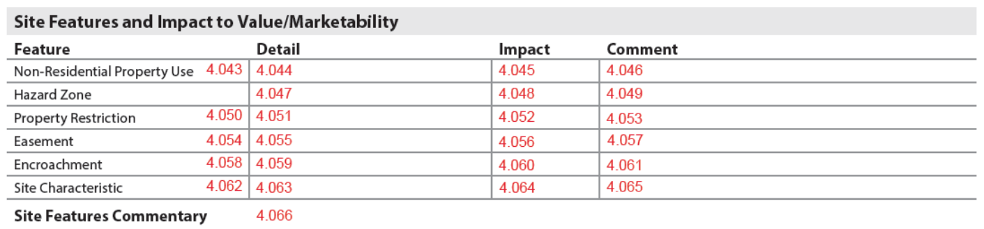
Non-Residential Property Use#
The appraiser must carefully analyze and report on any significant non-residential uses of the subject property in this section when Site Owned in Common (3.015) is No. This row only displays in the Site Features table when Site Owned in Common is No and Non-Residential Uses on Property (4.017) is Yes.
- When Site Owned in Common is Yes, the details of non-residential use for a specific unit, including whether the property qualifies as live / work space, are reported in the Unit Interior section (10.026-10.028).
- Commercial space in project buildings is reported in the Project Information section (18.069).
Site: Site Features - Non-Residential Property Use
| Report Field ID | Report Label | When to Include | Allowable Answers / Format | Definition / Additional Guidance |
|---|---|---|---|---|
| 4.043 4.044 |
Non-Residential Property Use (Detail) | Required if Non-Residential Use is Yes | Choose one or more allowable answers from the Definition / Additional Guidance column | The type(s) of non-residential use observed on the property. - Agricultural - Commercial (e.g., retail, day care, elder care, beauty or barber shop, doctor's office) - Industrial - Other (Describe) Note: Redisplays from 4.017. |
| 4.045 | Non-Residential Property Use (Impact) | Required if Non-Residential Use is Yes | Adverse, Beneficial, or Neutral | |
| 4.046 | Non-Residential Property Use (Comment) | Required if Non-Residential Use is Yes | Free-form | When Adverse or Beneficial, describe the impact to value and / or marketability. Additional commentary may be provided to include details and other information. |
Hazard Zone#
The appraiser must report all Hazard Zones that impact the subject property in this section. Examples such as Flood Zones and Lava Flow Zones are predefined and must be reported using the available selections. Select Other (Describe) to identify any zones that impact the subject property that are not predefined.
The Hazard Zone row always displays in the Site Features table.
Site: Site Features - Hazard Zone
| Report Field ID | Report Label | When to Include | Allowable Answers / Format | Definition / Additional Guidance |
|---|---|---|---|---|
| 4.047 | Hazard Zone (Detail) |
Always required | Choose one or more allowable answers from the Definition / Additional Guidance column | Hazard Zone: The geographic area, as specified by a government entity, documenting a potential risk to the property. - FEMA Special Flood Hazard Area - USGS Lava Flow Zone - None (No Hazard Zone Noted) - Other (Describe) |
| 4.047 | Hazard Zone (Detail) |
Required if Hazard Zone is USGS Lava Flow Zone | USGS Lava Flow Zone 1 to 9 | Lava Flow Zone: Defined by the United States Geological Survey to identify the most dangerous Lava Flow Zone in which the property, in whole or in part, is located. Note: If the property is in multiple Lava Flow Zones, report the most severe rating, and note the other Lava Flow Zones in Hazard Zone Comment. |
| 4.048 | Hazard Zone (Impact) | Required if property is in a hazard zone | Adverse, Beneficial, or Neutral | |
| 4.049 | Hazard Zone (Comment) | Required if Impact is Adverse, or as needed | Free-form | Hazard Zone Comment When Adverse, describe the impact to value and / or marketability. Additional commentary may be provided to include details and other information. |
Property Restriction#
The appraiser must identify property restrictions or encumbrances affecting the subject property in this subsection. Restrictions are identified using the most appropriate description from the list provided. If there are multiple restrictions, choose all that apply.
There is one row in the Site Features table for each Property Restriction. If there are no property restrictions, this row does not display.
Site: Site Features - Property Restriction
| Report Field ID | Report Label | When to Include | Allowable Answers / Format | Definition / Additional Guidance |
|---|---|---|---|---|
| 4.050 4.051 |
Property Restriction (Detail) |
If applicable | Choose one or more allowable answers from table (Property Restriction) | Property Restriction: Limitation(s) on the use, development, or transfer of a property. - Age - Historic Preservation - Income - Land Use - Rental - Sale Price - Other (Describe) |
| 4.052 | Property Restriction (Impact) | Required for each property restriction | Adverse, Beneficial, or Neutral | |
| 4.053 | Property Restriction (Comment) | Required for each property restriction if Impact is Adverse or Beneficial, or as needed | Free-form | When Adverse or Beneficial, describe the impact to value and / or marketability. Additional commentary may be provided to include details and other information. |
Property Restriction (Choose all that apply)
| Allowable Answer | Definition / Additional Guidance |
|---|---|
| Age | A restriction that limits the conveyance and ownership of the property based on an individual meeting a specified age threshold (e.g., 55+ communities). |
| Historic Preservation | A restriction that prevents owner from altering the property in its entirety or specific portion of the property to preserve its historical relevance or character. |
| Income | A restriction that limits the conveyance and ownership of the property based on an individual meeting income requirements. Note: For affordable housing programs, select both Income and Sale Price, if applicable. |
| Land Use | A restriction that controls use of the land. |
| Rental | A restriction on the amount of rent that can be charged or increased in a certain period (e.g., rental cap, rent control). |
| Sale Price | A restriction that places a sale price threshold on the property (e.g., minimum sale price, maximum sale price). Note: For affordable housing programs, select both Income and Sale Price, if applicable. |
| Other (Describe) | Select Other to enter an answer that is not in the above list. |
Easement#
Easements affecting the subject property are identified in this subsection. The appraiser must identify easements granted by neighboring properties to the subject property, in addition to any easements granted by the subject property to a neighboring property. Use the most appropriate description from the list provided.
There is one row in the Site Features table for each Easement. If there are no easements, this row does not display.
Site: Site Features - Easement
| Report Field ID | Report Label | When to Include | Allowable Answers / Format | Definition / Additional Guidance |
|---|---|---|---|---|
| 4.054 4.055 |
Easement (Detail) | If applicable | Choose one or more allowable answers from the Definition / Additional Guidance column | Easement: A nonpossessory right to cross or otherwise use a portion of another property for a specified purpose. - Conservation - Drainage - Ingress/Egress - Utility (other than typical property utility easements) - Other (Describe) Note: Do not report easements that are typical or common to the market. |
| 4.056 | Easement (Impact) | Required for each easement | Adverse, Beneficial, or Neutral | |
| 4.057 | Easement (Comment) | Required for each easement if Impact is Adverse or Beneficial, or as needed | Free-form | When Adverse or Beneficial, describe the impact to value and / or marketability. Additional commentary may be provided to include details and other information, including if the easement is on a neighboring property. |
Encroachment#
Encroachments affecting the subject property are identified in this subsection using the most appropriate description from the list provided. The appraiser must identify encroachments by neighboring properties on the subject property in addition to any encroachments of the subject property on a neighboring property.
There is one row in the Site Features table for each Encroachment. If there are no encroachments, this row does not display.
Site: Site Features - Encroachment
| Report Field ID | Report Label | When to Include | Allowable Answers / Format | Definition / Additional Guidance |
|---|---|---|---|---|
| 4.058 4.059 |
Encroachment (Detail) | If applicable | Choose one or more allowable answers from the Definition / Additional Guidance column | Encroachment: An intrusion on a property when a stationary object crosses a neighboring property line (e.g., fence, shed, garage, tree). - Building - Driveway - Fence - Overhang - Other (Describe) Note: Photos or images may be provided for encroachments, which display in Site Exhibits with the caption "Encroachment". An additional caption may be provided, including the encroachment type and any other descriptive information as appropriate. |
| 4.059 | Encroachment (Detail) | Required for each encroachment | Choose an allowable answer from the Definition / Additional Guidance column | Encroachment Direction - Bordering Property Encroaching on Subject Property - Subject Property Encroaching on Bordering Property |
| 4.060 | Encroachment (Impact) | Required for each encroachment | Adverse, Beneficial, or Neutral | |
| 4.061 | Encroachment (Comment) | Required for each encroachment if Impact is Adverse or Beneficial, or as needed | Free-form | When Adverse or Beneficial, describe the impact to value and / or marketability. Additional commentary may be provided to include details and other information. |
Site Characteristics#
The appraiser must report on all site characteristics that impact the value and marketability and report details as necessary in this subsection.
There is one Site Characteristic row in the Site Features table for each Site Characteristic. If there are no significant site characteristics, this row does not display.
Example of multiple site characteristics:

Site Characteristics
| Report Field ID | Report Label | When to Include | Allowable Answers / Format | Definition / Additional Guidance |
|---|---|---|---|---|
| 4.062 4.063 |
Site Characteristic (Detail) | Required for each site characteristic | Choose one or more allowable answers from table (Site Characteristic) | Site Characteristic: A given characteristic associated with the site. - None - Coastal Barrier Resources System - Drainage - Excess Land - Landlocked - Landscaping - Road Frontage - Shape - Soil Suitability - Surplus Land - Topography - Wetlands - Zero Lot Line - Other (Describe) Notes: - Select the Site Characteristics that impact value and / or marketability, or as needed. - Photos or images for the indicated site characteristic may be provided, which display in Site Exhibits with the caption "Site Characteristic". An additional caption including the site characteristic type and any other descriptive information as appropriate may be provided. |
| 4.063 | Site Characteristic (Detail) | Required if Site Characteristic is Topography | Choose one or more allowable answers from the Definition / Additional Guidance column | Topography Type: The shape and features of land surface. - Flat - Rocky - Rolling - Sloping - Other (Describe) |
| 4.063 | Site Characteristic (Detail) | Required if Site Characteristic is Drainage | Choose one or more allowable answers from the Definition / Additional Guidance column | Site Drainage Reason: The drainage reason that may impact the property. - Evidence of Erosion (observable degradation of the site, such as water runoff or sinkhole) - Improper Grading (water drains towards the foundation) - Standing Water - Other (Describe) |
| 4.064 | Site Characteristic (Impact) | Required for each site characteristic | Adverse, Beneficial, or Neutral | |
| 4.065 | Site Characteristic (Comment) | Required for each site characteristic if Impact is Adverse or Beneficial, or as needed | Free-form | When Adverse or Beneficial, describe the impact to value and / or marketability. Additional commentary may be provided to include details and other information. |
Site Characteristic (Choose all that apply)
| Allowable Answer | Definition / Additional Guidance |
|---|---|
| None | If there are no significant site characteristics, select None and the Site Characteristic row does not display. |
| Coastal Barrier Resources System | Areas protected by the Coastal Barrier Resource Act (CBRA) of 1982, which encourages the conservation of hurricane prone, biologically rich coastal barriers. |
| Drainage | The movement of water away from the site (e.g., slope, surface, subsurface). Note: If applicable, Drainage 22.03.11 displays as a separate row in the Sales Comparison Approach section. |
| Excess Land | Land beyond what is required to support the existing improvements of the site that can be subdivided and sold. |
| Landlocked | A site without legal access to a public thoroughfare (without easements). |
| Landscaping | External portions of the site improved for functionality or aesthetic quality (e.g., lawn coverage, vegetation, shrubs, trees, gardens, and paths). |
| Road Frontage | A strip or extent of land abutting a road that impacts value and / or marketability. |
| Shape | The outline of a site per legal boundaries. |
| Soil Suitability | Physical properties of the soil suitable to support the current or proposed property development and use. |
| Surplus Land | Land beyond what is required to support the existing improvements of the site that cannot be subdivided and sold (does not have a separate highest and best use). |
| Topography | The terrain or relative elevation of site surfaces (e.g., rolling, sloping, rocky, level). Note: If applicable, Topography 22.03.10 displays as a separate row in the Sales Comparison Approach section. |
| Wetlands | Areas that are inundated or saturated by surface or ground water at a frequency and duration sufficient to support, and that under normal circumstances do support, a prevalence of vegetation typically adapted for life in saturated soil conditions. Wetlands generally include swamps, marshes, bogs, and similar areas. |
| Zero Lot Line | Residential real estate in which the primary structure comes up to, or very near to, the edge of the property line (e.g., rowhouses, garden homes, patio homes, and townhomes). |
| Other (Describe) | Select Other to enter an answer that is not in the above list. |
Site Features Commentary#
Site Features Commentary
| Report Field ID | Report Label | When to Include | Allowable Answers / Format | Definition / Additional Guidance |
|---|---|---|---|---|
| 4.066 | Site Features Commentary | If applicable | Free-form | Overall commentary for all site features, which could include information pertinent to site features that is not captured in the discrete data, or additional details to support the discrete data that is provided. |
Utilities and Impact to Value / Marketability#

Utilities
| Applies To | Report Field ID | Report Label | When to Include | Allowable Answers / Format | Definition / Additional Guidance |
|---|---|---|---|---|---|
| All | 4.067 | Broadband Internet Available | Always required | Yes | No | - Yes (high-speed internet access is available through a wired connection that is permanently integrated into the property, such as digital subscriber line (DSL), fiber-optic, or cable) - No (high-speed internet access is only available through non-wired connections that are not permanently integrated into the property, considered personal property, such as private satellite dish or mobile hotspots) |
| FHA/VA/USDA | 4.068 | Dwelling / Improvement Within Utility Easement | Required for FHA, USDA, and VA appraisals when Easement is Utility | Yes | No | Indicates whether any part of an improvement is located within the boundary of a utility easement. Reference the appropriate government agency appraisal guidelines for more information. |
Rows marked
FHA/VA/USDAare shaded green in the PDF: they apply only to FHA, VA, or USDA appraisals.
Information for Each Utility#
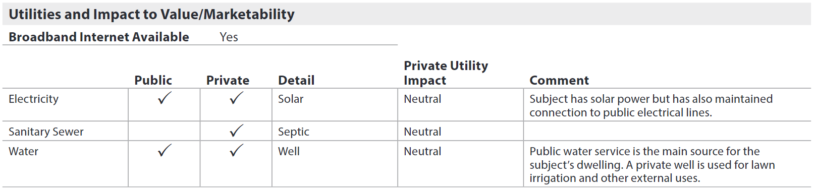
The appraiser must indicate whether each of the following utilities are connected to the site, and whether the utility is public or private.
- Electricity
- Gas
- Sanitary Sewer
- Water
- Other (Describe) - if applicable
For private utilities and for government agency appraisals, additional information is required for each utility.
Example:

Site: Utilities
| Applies To | Report Field ID | Report Label | When to Include | Allowable Answers / Format | Definition / Additional Guidance |
|---|---|---|---|---|---|
| All | 4.069 4.075 4.081 4.087 4.093 |
Electricity Gas Sanitary Sewer Water Other (Describe) |
Always required | Choose one or more allowable answers from the Definition / Additional Guidance column | Utility Type: Utilities that are permanently connected to the site. - Electricity - Gas - Sanitary Sewer - Water - Other (Describe) |
| All | 4.070 4.076 4.082 4.088 4.094 4.071 4.077 4.083 4.089 4.095 |
Public Private |
Always required for each utility that is connected to the site | Public or Non-Public |
Utility Ownership: Indicates whether the utility is a public utility or a non-public (private) utility. - If Public, a checkmark displays in the Public column for the indicated utility. - If Non-Public, a checkmark displays in the Private column for the indicated utility. - If neither public nor private, no checkmark displays for the row. - If there is no Electricity, Sanitary Sewer, or Water, provide details in Site Commentary (4.116). |
| All | 4.072 | Electricity (Detail) | Required if Utility Type is Electricity and Utility Ownership is Non-Public | Choose one or more allowable answers from table (Electricity Source) | Electricity Source: The delivery method of electricity to the property. - Battery Storage - Permanent Generator - Solar - Wind - Other (Describe) |
| FHA/VA/USDA | 4.084 | Sanitary Sewer (Detail) | Required if Utility Type is Sanitary Sewer and Utility Ownership is Non-Public | Choose one or more allowable answers from the Definition / Additional Guidance column | Sewer System - Cesspool - Septic - Other (Describe) |
| FHA/VA/USDA | 4.084 | Sanitary Sewer (Detail) | Required for FHA appraisals when there is no public sanitary sewer connected to the site (no checkmark is displayed in the Public column) | Yes | No | Public Sewer Available Not Connected - Yes (Public sewer available not connected) - No (Public sewer not available) Reference the appropriate government agency appraisal guidelines for more information. |
| FHA/VA/USDA | 4.090 | Water (Detail) |
Required if Utility Type is Water and Utility Ownership is Non-Public | Choose one or more allowable answers from table (Water Source) | Water Source: The source of water for the property. - Cistern - Hauled Water Holding Tank - Lake or Spring - Well - Other (Describe) |
| All | 4.072 4.078 4.084 4.090 4.096 |
Electricity Gas Sanitary Sewer Water Other (Describe) (Detail) |
Required for each utility that is connected to the site when Utility Ownership is Non-Public | Yes | No | Utility Shared: Indicates whether the utility is shared with another property. If Yes, "(Shared)" displays. |
| FHA/VA/USDA | 4.090 | Water (Detail) |
Required for FHA appraisals when there is no public water connected to the site (no checkmark is displayed in the Public column) | Yes | No | Public Water Available Not Connected - Yes (Public water available not connected) - No (Public water not available) Reference the appropriate government agency appraisal guidelines for more information. |
| FHA/VA/USDA | 4.090 | Water (Detail) |
If available for FHA, USDA, and VA appraisals when Water Source is Well | Choose an allowable value from table (Water Well Type) | Water Well Type: The type of individual water supply well. - Artesian - Drilled - Dug - Other (Describe) Reference the appropriate government agency appraisal guidelines for more information. |
| FHA/VA/USDA | 4.090 | Water (Detail) |
If applicable for FHA, USDA, and VA appraisals when Water Source is Well | Yes | No | Well Meets Distance Requirements: Indicates whether the well meets all applicable distance requirements as defined by the regulating agency. - Yes (well meets distance requirements) - No (well does not meet distance requirements) Reference the appropriate government agency appraisal guidelines for more information. |
| All | 4.073 4.079 4.085 4.091 4.097 |
Private Utility Impact | Required for each private utility | Adverse, Beneficial or Neutral | |
| All | 4.074 4.080 4.086 4.092 4.098 |
Comment | Required if Private Utility Impact is Adverse, or as needed | Free-form | Private Utility Comment or Public Utility Comment When Adverse, describe the impact to value and / or marketability. Additional commentary may be provided to include details and other information. Note: Fees for private utilities are reported here and not in the Project Information section. |
Rows marked
FHA/VA/USDAare shaded green in the PDF: they apply only to FHA, VA, or USDA appraisals.
Electricity Source (Choose all that apply)
| Applies To | Allowable Answer | Definition / Additional Guidance |
|---|---|---|
| All | Battery Storage | Permanent system designed to store energy that can be operated independently from the primary electricity source of the property. |
| All | Permanent Generator | Permanent backup electrical system that operates in the event of a power interruption. |
| All | Solar | |
| All | Wind | |
| FHA/VA/USDA | Other (Describe) | Select Other to enter an answer that is not in the above list. |
Rows marked
FHA/VA/USDAare shaded green in the PDF: they apply only to FHA, VA, or USDA appraisals.
Water Source (Choose all that apply)
| Applies To | Allowable Answer | Definition / Additional Guidance |
|---|---|---|
| All | Cistern | An artificial reservoir used for collecting and storing rain water. |
| All | Hauled Water Holding Tank | Holding tank used in conjunction with water purchased and hauled to the site. |
| All | Lake or Spring | |
| FHA/VA/USDA | Well | |
| FHA/VA/USDA | Other (Describe) | Select Other to enter an answer that is not in the above list. |
Rows marked
FHA/VA/USDAare shaded green in the PDF: they apply only to FHA, VA, or USDA appraisals.
Water Well Type (Choose one)
| Applies To | Allowable Answer | Definition / Additional Guidance |
|---|---|---|
| FHA/VA/USDA | Artesian | A well bored perpendicularly into water-bearing strata lying at an angle, so that natural pressure produces a constant supply of water with little or no pumping. |
| FHA/VA/USDA | Drilled | A well that is constructed by percussion or rotary-drilling machines. |
| FHA/VA/USDA | Dug | A well dug by shovel or backhoe, also referred to as bored. |
| FHA/VA/USDA | Other (Describe) | Select Other to enter an answer that is not in the above list. |
Rows marked
FHA/VA/USDAare shaded green in the PDF: they apply only to FHA, VA, or USDA appraisals.
Apparent Defects, Damages, Deficiencies (Site)#
The appraiser must report any significant items pertaining to the site, and must associate any defect, damage, or deficiency with the most appropriate section. These defects, damages, and deficiencies are items that:
- Rise to the level of recommending repair, replacement, or inspection by an individual with expertise in the industry, or
- Negatively affect the integrity / composition of the site itself, or
- Negatively affect the soundness or structural integrity of the improvements to the site, or
- Measurably impact the marketability or value of the property, or
- Require completion
Example:

Any other items that do not require repair, replacement, or inspection may also be reported using the Recommended Action of None.
Reference the appropriate government agency appraisal guidelines for specific requirements.

Apparent Defects, Damages, Deficiencies (Site)
| Report Field ID | Report Label | When to Include | Allowable Answers / Format | Definition / Additional Guidance |
|---|---|---|---|---|
| 4.099 | N/A | Always required | Yes |No | Site Defects Exist: Indicates whether there are apparent defects, damages. or deficiencies related to the Site section. - If No, "None" displays, and the Apparent Defects, Damages, Deficiencies (Site) table does not display. |
| 4.099 | N/A | Displays when Site Defects Exist is Yes | N/A | The items listed below represent the As Is condition as of the effective date of this report |
Information About Each Defect, Damage, or Deficiency#
Apparent Defects, Damages, Deficiencies (Site)
| Report Field ID | Report Label | When to Include | Allowable Answers / Format | Definition / Additional Guidance |
|---|---|---|---|---|
| 4.100 | Feature | Required for each defect, damage, or deficiency | Other (Describe) | Notes: - For the Site section, choose Other and briefly describe the feature with the defect, damage, or deficiency. - Photos or images must be provided for each physical defect, damage, or deficiency. These display in Site Exhibits as "Apparent Defects, Damages, Deficiencies" with the indicated Feature. An additional caption may be provided. |
| 4.101 | Location | Required for each defect, damage, or deficiency | Other (Describe) | For the Site section, choose Other and briefly describe the location of the defect, damage, or deficiency. |
| 4.102 | Description | Required for each defect, damage, or deficiency | Free-form | Description of the defect, damage, or deficiency. |
| 4.103 | Affects Soundness or Structural Integrity | Required for each defect, damage, or deficiency | Yes | No | Indicates whether the defect, damage, or deficiency affects the soundness and / or structural integrity of the improvement. |
| 4.104 | Recommended Action | Required for each defect, damage, or deficiency | Choose an allowable answer from the Definition / Additional Guidance column | The recommended action for the defect, damage, or deficiency. - Completion - Inspection - Repair (includes replacement) - None (does not require repair, replacement, completion, or inspection) Note: - If Completion, Inspection, or Repair is reported for any defect, damage, or deficiency - The report must be made subject to the resolution of the item (Market Value Condition 26.009 cannot be As Is). - If Repair is selected, the estimated cost to repair may be provided in the Reconciliation section. |
Site Valuation Methodology#
This subsection enables Opinion of Site Value (and land comparables if applicable) to be included in the URAR when there is no Cost Approach section. It displays here when Site Value Developed by Appraiser is Yes.
Site: Site Valuation Methodology
| Report Field ID | Report Label | When to Include | Allowable Answers / Format | Definition / Additional Guidance |
|---|---|---|---|---|
| Not on Report | This is an appraiser input that does not display | Required when there is no Cost Approach section | Yes | No | Site Value Developed by Appraiser - Yes (The Site Valuation Methodology subsection is included in the Site section) - No (The Site Valuation Methodology subsection is not included in the Site section) |
Site Value and Site Valuation Method#

Site Value and Site Valuation Method
| Report Field ID | Report Label | When to Include | Allowable Answers / Format | Definition / Additional Guidance |
|---|---|---|---|---|
| 4.105 | Opinion of Site Value | Required if Site Value Developed by Appraiser is Yes | Dollar amount | The dollar value estimated for the property site (e.g., land that is improved so that it is ready to be used for a specific purpose). Can be 0, such as when Property Rights Appraised is Leasehold. |
| 4.106 | Primary Site Valuation Method | Required if Site Value Developed by Appraiser is Yes | Choose an allowable answer from table (Primary Site Valuation Method) | The method by which the site value is calculated. - Allocation - Extraction - Sales Comparison - Other (Describe) |
Primary Site Valuation Method (Choose one)
| Allowable Answer | Definition / Additional Guidance |
|---|---|
| Allocation | An estimation of land value in which sales of improved properties are analyzed to establish a typical ratio of land value to total property value. This ratio is applied to the property being appraised to arrive at an estimated value for the land. |
| Extraction | An estimation of land value in which the depreciated cost of the improvements on the improved property is estimated and deducted from the total sale price to arrive at an estimated value for the land. |
| Sales Comparison | Identifies sales of vacant land and / or sites and applies an adjustment process to the sale price to determine an indicated value or range of value for the subject site. Note: If this answer is selected, land comparables (4.107-4.114) must be provided. |
| Other (Describe) | Select Other to enter an answer that is not in the above list. |
Information for each Land Comparable#
The Land Comparables table displays if Primary Site Valuation Method is Sales Comparison, and the "When to Include" column in this table reflects this.

Site: Site Valuation Methodology - Land Comparables
| Report Field ID | Report Label | When to Include | Allowable Answers / Format | Definition / Additional Guidance |
|---|---|---|---|---|
| 4.107 | # | Required for each land comparable | 1, 2, 3 … | Land Comparable # |
| 4.108 | Address | If available for each land comparable | Free-form | Land Comparable Street Address If the street address is unavailable or has not yet been assigned, provide any information necessary to identify the property. |
| 4.108 | Address | Required for each land comparable | Free-form | Land Comparable City, State, ZIP Code |
| 4.109 | County | Required for each land comparable | Free-form | Name of the county or parish as defined by the state. Note: If the land comparable is not located in any county (e.g., located in an independent city), enter the name of the local municipality or district in which the property is located. |
| 4.110 | Data Source | Required for each land comparable | Choose one or more allowable answers from the Definition / Additional Guidance column | Land Comparable Data Source - Assessor Record - Builder or Developer - Data Aggregator - Exterior Inspection - HOA - Land Survey - Lender - MLS - Previous Appraisal File - Property Owner - Real Estate Agent - Zoning - Other (Describe) |
| 4.110 | Data Source | Required when Land Comparable Data Source is MLS, or if applicable for other data sources | Free-form | Data Source Identifier: A unique number or identifier assigned to the land comparable by the data source. Notes: - If Land Comparable Data Source is MLS, the MLS number is required. - If a data source has an identifier, it must be reported on the URAR. |
| 4.111 | Assessor Parcel Number (APN) | If available for each land comparable | Free-form | A number assigned to parcels of real property by the tax assessor of a particular jurisdiction for purposes of identification and record-keeping. |
| 4.112 | Site Size | Required for each land comparable | Number of acres, square feet, hectares, or square meters | The total area of the site, including all parcels. - For area less than 1 acre, use square feet in whole numbers (e.g., 27,840 sq. ft.). - For area that is 1 acre or more, use acres to 2 decimals (e.g., 1.25 acres). - If using the metric system, for area less than 1 hectare, use square meters in whole numbers (e.g., 7,500 sq. m.). - If using the metric system, for area that is 1 hectare or more, use hectares to 2 decimals (e.g., 1.25 hectares). |
| 4.113 | Sale Date | Required for each land comparable | mm/dd/yyyy | |
| 4.114 | Price | Required for each land comparable | Dollar amount | Sale Price |
Reconciliation of Site Value#
Reconciliation of Site Value
| Report Field ID | Report Label | When to Include | Allowable Answers / Format | Definition / Additional Guidance |
|---|---|---|---|---|
| 4.115 | Reconciliation of Site Value | Required if Site Value Developed by Appraiser is Yes | Free-form | Commentary should include information pertinent to the Opinion of Site Value that is not captured in the discrete data, or additional details to support the discrete data that is provided, including access, utilities, zoning, views, or site influences of the land comparables in relation to the subject. |
| See iGuide | Map of Land Comparables | If relevant | Image | A map of the subject and land comparables should be included, which displays in Site Exhibits with the caption "Map of Land Comparables". An additional caption may be provided to further identify the image. Reference published guidelines by the GSEs, government agencies, or other identified secondary market participants for specific guidance. |
Site Commentary#

Site Commentary
| Report Field ID | Report Label | When to Include | Allowable Answers / Format | Definition / Additional Guidance |
|---|---|---|---|---|
| 4.116 | Site Commentary | If applicable | Free-form | Commentary could include information pertinent to the Site section that is not captured in the discrete data, or additional details to support the discrete data that is provided. |
Site Exhibits#
All photos or images related to the Site section are displayed in the Site Exhibits subsection. If there are no photos or images, this subsection does not display.
Site Exhibits
| Report Field ID | Report Label | When to Include | Allowable Answers / Format | Definition / Additional Guidance |
|---|---|---|---|---|
| See iGuide | Site Exhibits | If applicable | Image | An image of the property (site) boundaries, such as a Plat Map, may be provided which displays in Site Exhibits with the caption "Property Boundaries". An additional caption to further identify the image may be provided. |
| See iGuide | Site Exhibits | If applicable | Photos or images | Photos or images relevant to the Site section may be provided, which display in Site Exhibits. If the photo or image is not specifically indicated above, provide a caption to further identify the photo or image. |