Section 04
Site
Appendix B-1, page 123
The Site section provides information about the characteristics of the parcel(s) such as size, property access, site influences, utilities, and property restrictions. This section provides space for additional commentary, exhibits, and information about any apparent defects, damages, or deficiencies related to the site.
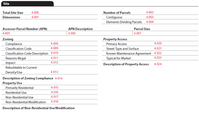
The Site section always displays in the report; however, there are multiple data points from the Subject Property section that determine conditionality, such as:
- Subject Site Owned in Common - LandOwnedInCommonIndicator (UID: 0100.0047, FID: 3.015)
- PropertyInProjectIndicator (UID: 0100.0065, FID: Not on report)
- Subject Property - ProjectLegalStructureType (UID: 2500.0168)
- Condominium (FID: 3.011)
- Coop (FID: 3.012)
- Condop (FID: 3.013)
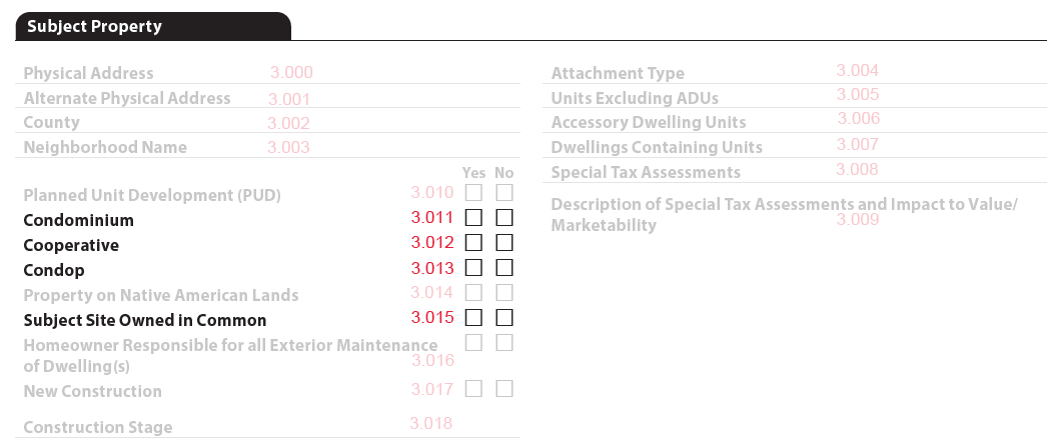
Site Size and Parcels#
When Subject Site Owned in Common - LandOwnedInCommonIndicator (UID: 0100.0047, FID: 3.015) = "false"
- Total Site Size - LotSizeAreaMeasure (UID: 1500.0093, FID: 4.000) displays
- For area less than 1 acre, use square feet in whole numbers (e.g., 27,840 Sq. Ft.).
- For area that is 1 acre or more, use acres to 2 decimals (e.g., 1.25 Acres).
- If using the metric system, for area less than 1 hectare, use square meters in whole numbers (e.g., 7,500 Sq. M.).
- If using the metric system, for area that is 1 hectare or more, use hectares to 2 decimals (e.g., 1.25 Hectares).
- When Number of Parcels - ParcelCount (UID: 1500.0094, FID: 4.002) > 1 (Figure 4 - 1)
- Contiguous - ParcelsContiguousIndicator (UID: 1500.0095, FID: 4.003) displays
- When false, display "No"
- When true, display "Yes"
- Elements Dividing Parcels - ParcelSeparatorType (UID: 1500.0020, FID: 4.004) displays
- When there are multiple parcels, separate with "|" (e.g., Body of Water | Road)
- Contiguous - ParcelsContiguousIndicator (UID: 1500.0095, FID: 4.003) displays
- Dimensions - SiteDimensionsDescription (UID: 1500.0160, FID: 4.001) display when GovernmentAgencyAppraisalIndicator (UID: 1000.0028, FID: Not on report) = "true" and is provided
Figure 4 - 1

Information for each parcel#
For each parcel identified, additional data is required:
- Assessor Parcel Number (APN) - ParcelIdentificationType (UID: 1500.0026, FID: 4.005)
- Display unless ProjectLegalStructureType = "Cooperative" or when an APN is not available for the parcel.
- APN Description - ParcelDescriptionClassificationType (UID: 1500.0023, FID: 4.006)
- Parcel Size - ParcelAreaMeasure (UID: 1500.0022, FID: 4.007)
- For area less than 1 acre, use square feet in whole numbers (e.g., 27,840 Sq. Ft.).
- For area that is 1 acre or more, use acres to 2 decimals (e.g., 1.25 Acres).
- If using the metric system, for area less than 1 hectare, use square meters in whole numbers (e.g., 7,500 Sq. M.).
- If using the metric system, for area that is 1 hectare or more, use hectares to 2 decimals (e.g., 1.25 Hectares).
- Each parcel displays as a separate row in the table.
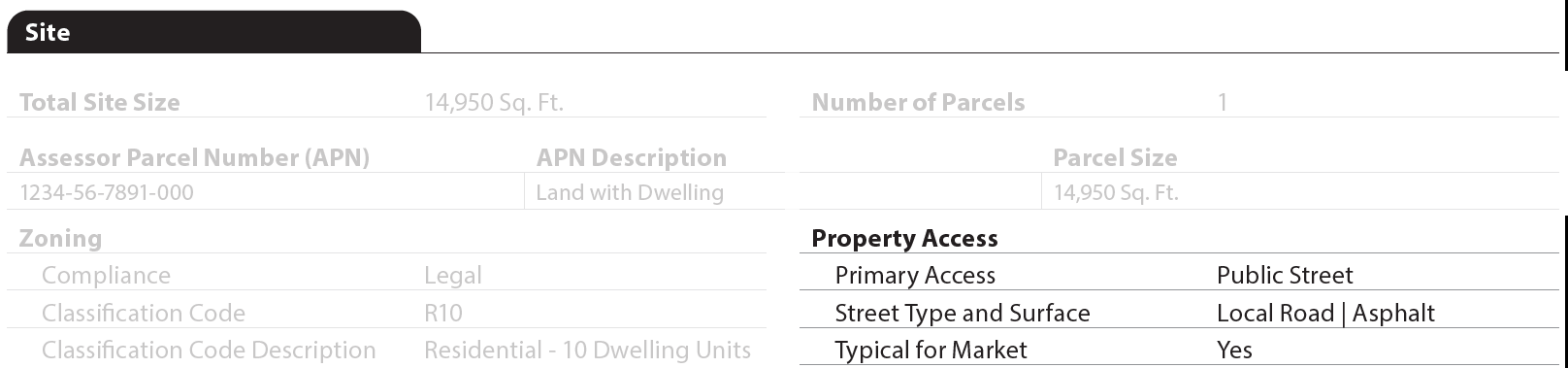
Example: For a single-family property where the subject site is not owned in common. (Figure 4 - 2)
Figure 4 - 2

Example: For a condo where subject site is owned in common. (Figure 4 - 3)
Figure 4 - 3

Zoning#
- Under Zoning, Compliance - SiteZoningComplianceType (UID: 1500.0125, FID: 4.008) always displays.
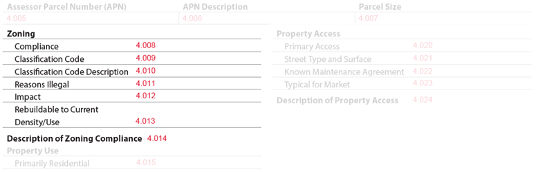
When Compliance - SiteZoningComplianceType = "Legal" display:
- Classification Code - SiteZoningClassificationIdentifier (UID: 1500.0122, FID: 4.009)
- Classification Code Description - SiteZoningClassificationDescription (UID: 1500.0123, FID: 4.010)
- Description of Zoning Compliance (displays only when provided) - SiteZoningComplianceDescription (UID: 1500.0124, FID: 4.014)
When Compliance - SiteZoningComplianceType = "Illegal" display:
- Classification - Code SiteZoningClassificationIdentifier (UID: 1500.0122, FID: 4.009)
- Classification Code Description - SiteZoningClassificationDescription (UID: 1500.0123, FID: 4.010)
- Reasons Illegal - SiteZoningComplianceIllegalReasonType (UID: 1500.0128, FID: 4.011)
- If there are multiple Reasons Illegal, display as stacked on separate lines.
- Impact - ValuationAnalysisCategoryType (UID: 1500.0191, FID: 4.012)
- Description of Zoning Compliance - SiteZoningComplianceDescription (UID: 1500.0124, FID: 4.014)
When Compliance - SiteZoningComplianceType = "LegalNonconforming" display:
- Classification Code - SiteZoningClassificationIdentifier (UID: 1500.0122, FID: 4.009)
- Classification Code Description - SiteZoningClassificationDescription (UID: 1500.0123, FID: 4.010)
- Impact - ValuationAnalysisCategoryType (UID: 1500.0191, FID: 4.012)
- Rebuildable to Current Density/Use - ZoningPermitRebuildToCurrentDensityIndicator (UID: 1500.0127, FID: 4.013)
- Description of Zoning Compliance (when provided) - SiteZoningComplianceDescription (UID: 1500.0124, FID: 4.014)
When Compliance - SiteZoningComplianceType = "NoZoning" display:
- Impact - ValuationAnalysisCategoryType (UID: 1500.0191, FID: 4.012)
- Description of Zoning Compliance (when provided) - SiteZoningComplianceDescription (UID: 1500.0124, FID: 4.014)
Property Use#
The Property Use subheading displays when Subject Site Owned in Common - LandOwnedInCommonIndicator (UID: 0100.0047, FID: 3.009) = "false".
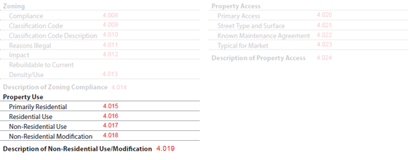
Site: Property Use
| Report Field ID | Report Label | Unique ID | MISMO Data Point Name | Display Rules Display when LandOwnedInCommonIndicator = "false" AND… |
|---|---|---|---|---|
| 4.015 | Primarily Residential | 1500.0036 | PropertyPrimarilyResidentialUseIndicator | … PropertyMixedUsageIndicator = "true" |
| 4.016 | Residential Use | 1500.0037 | ResidentialUsePercent | … PropertyMixedUsageIndicator = "true" AND GovernmentAgencyAppraisalIndicator = "true" − Display with % sign |
| 4.017 | Non-Residential Use | 1500.0039 | NonResidentialUseType | … PropertyMixedUsageIndicator = "true" When there are multiple, display as stacked on separate lines − When "false", display "None" |
| 4.018 | Non-Residential Modification | 1500.0032 | NonResidentialModificationIndicator | … PropertyMixedUsageIndicator = "true" |
| 4.019 | Description of Non-Residential Use/Modification | 1500.0033 | NonResidentialUseDescription | … PropertyMixedUsageIndicator = "true" |
Property Access#
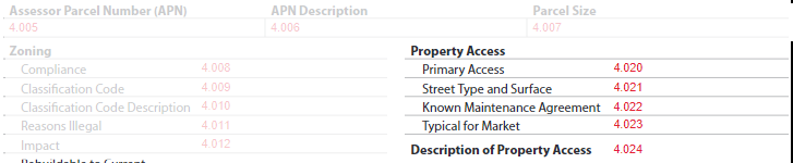
- Primary Access - PropertyPrimaryEntryExitMethodType (UID: 1500.0055, FID: 4.020) always displays.
Site: Property Access
| Report Field ID | Report Label | Unique ID | MISMO Data Point Name | Display Rules |
|---|---|---|---|---|
| 4.020 | Primary Access | 1500.0055 | PropertyPrimaryEntryExitMethodType | Always displays |
| 4.021 | Street Type and Surface | 1500.0049 1500.0047 |
StreetAccessType ImprovedSurfaceMaterialType |
Display when (PropertyPrimaryEntryExitMethodType = "PublicStreet" OR "PrivateStreet") − Display Street Access Type and Surface Material Type separated by "|" (Figure 4 - 4) − If there are multiple, display as "stacked" |
| 4.022 | Known Maintenance Agreement | 1500.0052 | PrivateStreetMaintenanceAgreementExistIndicator | Display when PropertyPrimaryEntryExitMethodType = "PrivateStreet" |
| 4.023 | Typical for Market | 1500.0054 | PropertyAccessTypicalToMarketIndicator | Always displays |
| 4.024 | Description of Property Access | 1500.0053 | PropertyAccessDescription | PropertyAccessTypicalToMarketIndicator = "false" OR Exists |
Figure 4 - 4
Site Influence#
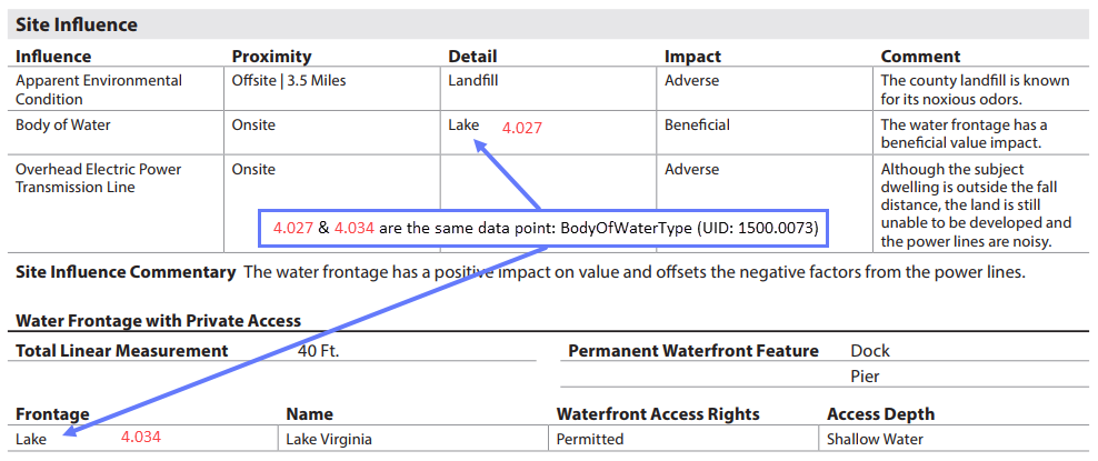
The Site Influence subsection always displays. The details of the table vary based on the influence selected. Each site influence, environmental condition, or body of water selected from the enumerated list displays as a separate row in the table. An image may be included for each site influence.
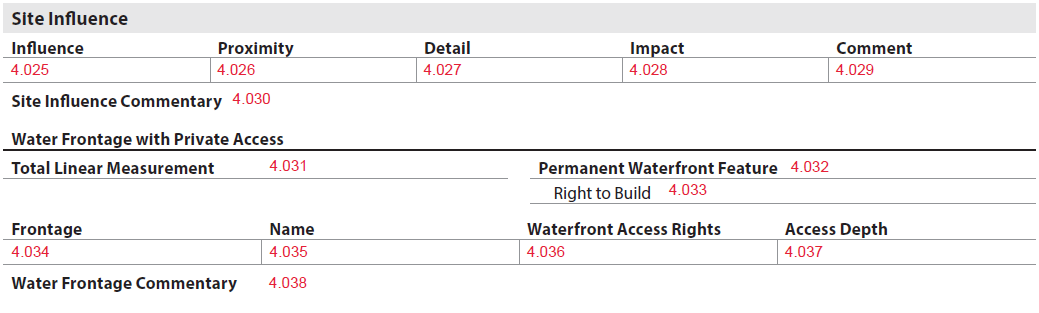
Influence - SiteInfluenceType (UID: 1500.0087, FID: 4.025) always displays. (Figure 4 - 5)
Figure 4 - 5

Site: Site Influence
| Report Field ID | Report Label | Unique ID | MISMO Data Point Name | Display Rules |
|---|---|---|---|---|
| 4.025 | Influence | 1500.0087 | SiteInfluenceType | Always displays − Each SiteInfluenceType displays once (Figure 4 - 6), unless: - ApparentEnvironmentalCondition - BodyOfWater |
| 4.026 | Proximity | 1500.0015 | DistanceFromPropertyLinearMeasure @LinearUnitOfMeasureType |
Display when EnvironmentalConditionType <> "None" AND (SiteInfluenceProximityType = "Bordering" OR "Offsite") − Display Proximity followed by a "|" then the Distance and Unit of Measure (Feet, Kilometers, Meters, Miles) in same cell (e.g., Offsite | 1 Mile) − For distances less than one mile display a leading zero to the left of the decimal point, e. g., Offsite | 0.02 Mile |
| 1500.0018 | EnvironmentalConditionProximityType | Display when EnvironmentalConditionType <> "None" | ||
| 1500.0076 | BodyOfWaterProximityType | Display when SiteInfluenceType = "BodyOfWater" | ||
| 1500.0086 | SiteInfluenceProximityType | Display when SiteInfluenceType <> "BodyOfWater" | ||
| 4.027 | Detail | 1500.0068 | SpecialAirportHazardZoneType | Display when GovernmentAgencyAppraisalIndicator = "true" AND SiteInfluenceType = "Airport" |
| 1500.0084 | InfluenceMeetsPolicyRequirementsIndicator | Display when GovernmentAgencyAppraisalIndicator = "true" AND (SiteInfluenceType = "LocalDistributionLine" OR "OverheadElectricPowerTransmissionLine" OR "HighPressureGasLine") |
||
| 1500.0016 | EnvironmentalConditionType | Display when EnvironmentalConditionType <> "None" − If <> "None", display a separate "Apparent Environmental Condition" row in the Site Influence table for each environmental condition − If "None", do not display a row for "Apparent Environmental Conditions" |
||
| 1500.0073 | BodyOfWaterType | Display when SiteInfluenceType = "BodyOfWater" − If there are multiple Bodies of Water, display each on a separate row in the Site Influence table |
||
| 4.028 | Impact | 1500.0177 | ValueMarketabilityImpactType | Display when EnvironmentalConditionType <> "None" |
| 4.029 | Comment | 1500.0176 | EnvironmentalConditionIdentifiedDescription | Display when EnvironmentalConditionType <> "None" |
| 1500.0247 | BodyOfWaterDescription | Display when SiteInfluenceType = "BodyOfWater" AND (ValueMarketabilityImpactType = "Adverse" OR "Beneficial") OR Exists |
||
| 1500.0181 | SiteInfluenceDescription | Display when SiteInfluenceType = "BodyOfWater" AND (ValueMarketabilityImpactType = "Adverse" OR "Beneficial") OR (InfluenceMeetsPolicyRequirementsIndicator = "false") OR Exists |
||
| Site Influence Commentary | ||||
| 4.030 | Commentary | 1500.0257 | ValuationCommentText | Display when exists |
Figure 4 - 6
Water Frontage with Private Access#
When Influence - SiteInfluenceType (UID: 1500.0087, FID: 4.025) <> "BodyOfWater", Water Frontage with Private Access subsection does not display.
When Influence - SiteInfluenceType (UID: 1500.0087, FID: 4.025) = "BodyOfWater", Water Frontage with Private Access must be determined for each body of water.
- When PrivateAccessIndicator (UID: 1500.0075) = "false" for all bodies of water, this subsection does not display.
- When PrivateAccessIndicator (UID: 1500.0075) = "true" for 1 or more body of water, additional information is needed for each instance, which displays on a separate row in the Water Frontage with Private Access table:
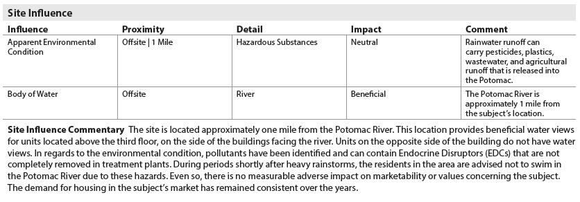
- Total Linear Measurement - WaterFrontageTotalLengthLinearMeasure, @LinearUnitOfMeasureType (UID: 1500.0091, FID: 4.031) displays ▪ Display Linear Measurement and Unit of Measure in same cell
- Permanent Waterfront Feature - WaterfrontFeatureType (UID: 1500.0082, FID: 4.032) displays, e.g., Beach, Dock, etc. ▪ When there are multiple waterfront features, display as stacked on separate lines.
- Right to Build - WaterfrontDevelopmentRightsIndicator (UID: 1500.0092, FID: 4.033) displays when WaterfrontFeatureType = "None"
- Frontage - BodyOfWaterType (UID: 1500.0073, FID: 4.034) - e.g., Bay, Canal, Cove, etc. ▪ This field redisplays from Site Influence Detail - FID: 4.027 (Figure 4 - 7)
- Name - BodyOfWaterName (UID: 1500.0072, FID: 4.035) displays when provided
- Waterfront Access Rights - WaterAccessRightType (UID: 1500.0079, FID: 4.036) displays
- Access Depth - WaterAccessDepthType (UID: 1500.0197, FID: 4.037) displays
- Water Frontage Commentary - ValuationAnalysisCategoryType (UID: 1500.0253, FID: 4.037) = "WaterFrontages" displays when provided
Figure 4 - 7
View and Impact to Value/Marketability#
The View and Impact to Value/Marketability subsection always displays. Additional information is always required for each view. Each view displays as a separate row in the table. (Figure 4 - 8)

Site: View and Impact to Value/Marketability
| Report Field ID | Report Label | Unique ID | MISMO Data Point Name | Display Rules |
|---|---|---|---|---|
| 4.039 | View | 1500.0120 | ViewType | Always displays |
| 4.039 | (Primary) | 1500.0117 | ViewPrimaryIndicator | Display when multiple views are provided − (Primary) displays to the right of the view − The primary view must be in the first row − When there is only 1 view, (Primary) does not display |
| 4.040 | Range of View | 1500.0118 | ViewRangeType | Always displays |
| 4.041 | Impact | 1500.0184 | ValueMarketabilityImpactType | Always displays |
| View Commentary | ||||
| 4.042 | View Commentary | 1500.0257 | ValuationCommentText | Display when exists |
Figure 4 - 8

Site Features and Impact to Value/Marketability#
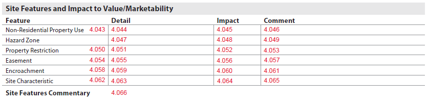
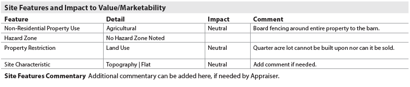
The appearance of the Site Features and Impact to Value/Marketability table varies based on the details of the property being appraised.
- Non-Residential Property Use
- Hazard Zone
- Property Restrictions (EncumbranceType = "ConditionsCovenantsRestrictions")
- Easements (EncumbranceType = "Easements")
- Encroachments (EncumbranceType = "Encroachments")
- Site Characteristics
Site: Site Features and Impact to Value/Marketability
| Report Field ID | Report Label | Unique ID | MISMO Data Point Name | Display Rules |
|---|---|---|---|---|
| 4.043 | Non-Residential Property Use | 1500.0034 | PropertyMixedUsageIndicator | Display when LandOwnedInCommonIndicator = "false" |
| 4.044 | Detail | 1500.0040 | NonResidentialUseType | Display when LandOwnedInCommonIndicator = "false" AND PropertyMixedUsageIndicator = "true" − If there are multiple non-residential uses, they are displayed in the same row and separated by a pipe (|) |
| 4.045 | Impact | 1500.0190 | ValueMarketabilityImpactType | Display when @ValuationUseType = "SubjectProperty" AND PropertyMixedUsageIndicator = "true" |
| 4.046 | Comment | 1500.0189 | ValuationCommentText | Display when @ValuationUseType = "SubjectProperty" AND PropertyMixedUsageIndicator = "true" |
| Hazard Zone | Always displays | |||
| 4.047 | Detail | 1500.0042 1500.0045 |
HazardZoneType LavaFlowZoneCode |
Always displays − When HazardZoneType = "USGSLavaFlowZone" display the HazardZoneType followed by LavaFlowZoneCode |
| − When there are multiple hazard zones, they are displayed in the same row and separated by a pipe (|) − When "None", "No Hazard Zone Noted" displays (Figure 4 - 9) |
||||
| 4.048 | Impact | 1500.0187 | ValueMarketabilityImpactType | Display when @ValuationUseType = "SubjectProperty" AND HazardZoneType <> "None" |
| 4.049 | Comment | 1500.0186 | ValuationCommentText | Display when (@ValuationUseType = "SubjectProperty" AND HazardZoneType <> "None" AND ValueMarketabilityImpactType = "Adverse") OR (@ValuationUseType = "SubjectProperty" AND HazardZoneType <> "None" AND (ValueMarketabilityImpactType = "Beneficial" OR "Neutral") AND Exists) |
| 4.050 | Property Restriction | 1500.0012 | EncumbranceType | Display when exists - − Each Property Restriction displays on a separate row - − When there are no property restrictions, this row does not display |
| 4.051 | Detail | 1500.0002 | RestrictionType | Display when EncumbranceType = "ConditionsCovenantsRestrictions" |
| 4.052 | Impact | 1500.0171 | ValueMarketabilityImpactType | Display when EncumbranceType = "ConditionsCovenantsRestrictions" |
| 4.053 | Comment | 1500.0170 | RestrictionDescription | Display when (EncumbranceType = "ConditionsCovenantsRestrictions" AND (ValueMarketabilityImpactType = "Adverse" OR "Beneficial")) OR (EncumbranceType = "ConditionsCovenantsRestrictions" AND ValueMarketabilityImpactType = "Neutral" AND Exists) |
| 4.054 | Easement | 1500.0012 | EncumbranceType | Display when exists - − Each Easement displays on a separate row - − When there are no easements, this row does not display |
| 4.055 | Detail | 1500.0004 | EasementType | Display when EncumbranceType = "Easement" |
| 4.056 | Impact | 1500.0173 | ValueMarketabilityImpactType | Display when EncumbranceType = "Easement" |
| 4.057 | Comment | 1500.0172 | EasementDescription | Display when (EncumbranceType = "Easement" AND (ValueMarketabilityImpactType = "Adverse" OR "Beneficial")) OR (EncumbranceType = "Easement" AND ValueMarketabilityImpactType = "Neutral" AND Exists) |
| 4.058 | Encroachment | 1500.0012 | EncumbranceType | Display when exists |
| - − Each Encroachment displays on a separate row - − When there are no encroachments, this row does not display |
||||
| 4.059 | Detail | 1500.0008 | EncroachmentDirectionType | Display as stacked when EncumbranceType = "Encroachment" |
| 1500.0009 | EncroachmentType | |||
| 4.060 | Impact | 1500.0175 | ValueMarketabilityImpactType | Display when EncumbranceType = "Encroachment" |
| 4.061 | Comment | 1500.0174 | EncroachmentDescription | Display when (EncumbranceType = "Encroachment" AND (ValueMarketabilityImpactType = "Adverse" OR "Beneficial")) OR (EncumbranceType = "Encroachment" AND ValueMarketabilityImpactType = "Neutral" AND Exists) |
| Site Characteristic | Displays when SiteFeatureType <> "None" | |||
| 4.063 | Detail | 1500.0062 | SiteFeatureType | Always displays − When "Topography", display Topography followed by TopographyType (UID: 1500.0065, FID: 4.058) separated by a pipe "|" − When "Drainage", display Drainage followed by SiteDrainageReasonType (UID: 1500.0060, FID: 4.058) separated by a pipe "|" − (e.g., Drainage | Standing Water) − Each Site Characteristic displays on a separate row |
| 4.064 | Impact | 1500.0180 | ValueMarketabilityImpactType | Display when SiteFeatureType <> "None" |
| 4.065 | Comment | 1500.0179 | SiteFeatureDescription | Display when (SiteFeatureType <> "None" AND (ValueMarketabilityImpactType = "Adverse" OR "Beneficial")) OR Exists |
| Site Features Commentary | ||||
| 4.066 | Site Features Commentary | 1500.0252 | ValuationAnalysisCategoryType | Display when ValuationAnalysisCategoryType = "SiteFeatures" AND Exists |
Figure 4 - 9
Utilities and Impact to Value/Marketability#
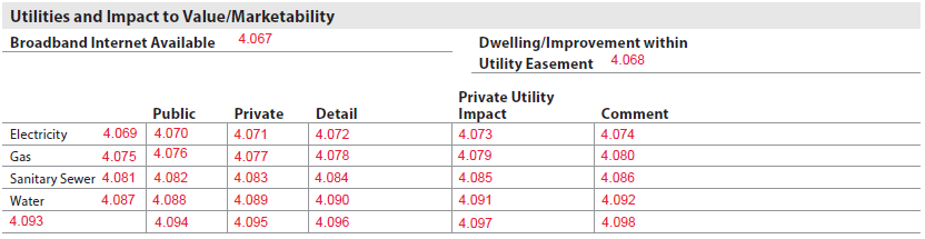
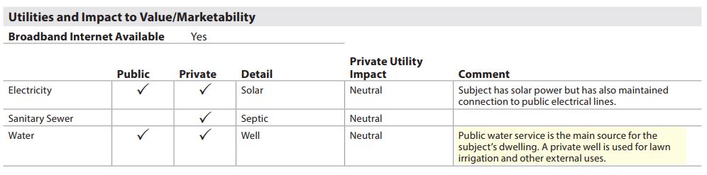
The Utilities and Impact to Value/Marketability subsection always displays. It indicates whether the utilities that are listed on the report are connected to the site, and whether the utility is public or private.
- Electricity, Sanitary Sewer, and Water always display as row headers and in alphabetical order on the report.
- Gas displays only when UtilityType (UID: 1500.0104, FID: 4.075) = "Gas" is indicated.
- Broadband Internet Available - BroadbandInternetAvailableIndicator (FID: 1500.0166, FID: 4.067)
- Always displays
- Dwelling/Improvement within Utility Easement - ImprovementInBoundaryOfEasementIndicator (UID: 1500.0007, FID: 4.068)
- Displays when EasementType = "Utility" AND GovernmentAgencyAppraisalIndicator (UID: 1000.0122, FID: Not on report) = "true"
- Public/Private - required for each utility indicated
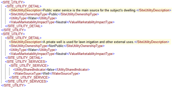
- When SiteUtilityOwnershipType (UID: 1500.0102, FID: 4.070, 4.076, 4.082, 4.088, 4.094) = "Public", a check mark displays under Public
- When SiteUtilityOwnershipType (UID: 1500.0102, FID: 4.071, 4.077, 4.083, 4.089, 4.095) = "NonPublic", a check mark displays under Private
- When both are indicated, display in the same row with check marks under Public and Private
- Detail - when SiteUtilityOwnershipType = "NonPublic", additional information is required.
- Electricity
▪ When UtilityType (UID: 1500.0104, FID: 4.069) = "Electricity":
- ElectricitySourceType (UID: 1500.0106, FID: 4.072), displays the enumerated value
- When UtilitySharedIndicator (UID: 1500.0103, FID: 4.072) = "true", display ElectricitySourceType followed by "(Shared)", in same cell.
- When UtilitySharedIndicator (UID: 1500.0103, FID: 4.072) = "false", does not display
- Gas
▪ When UtilityType (UID: 1500.0104, FID: 4.075) = "Gas":
- When UtilitySharedIndicator (UID: 1500.0103, FID: 4.078) = "true", display "(Shared)"
- When UtilitySharedIndicator (UID: 1500.0103, FID: 4.078) = "false", do not display
- Sanitary Sewer
▪ When UtilityType (UID: 1500.0104, FID: 4.081) = "SanitarySewer":
- SewerSystemType (UID: 1500.0166, FID: 4.084), displays the enumerated value
- If there are multiple sewer system types , separate by a "|"
- When UtilitySharedIndicator (UID: 1500.0103, FID: 4.084) = "true", display SewerSystemType followed by "(Shared)", in same cell.
- When UtilitySharedIndicator (UID: 1500.0103, FID: 4.084) = "false", do not display
- AND GovernmentAgencyAppraisalType (UID: 1000.0121, FID: 2.008) = "FHA" AND PublicSewerUtilityAvailableNotConnectedIndicator (UID: 1500.0168, FID: 4.084)
- When "true", display "Public sewer available not connected"
- When "false", display "Public sewer not available"
- SewerSystemType (UID: 1500.0166, FID: 4.084), displays the enumerated value
- Water
▪ When UtilityType (UID: 1500.0104, FID: 4.087) = "Water":
- WaterSourceType (UID: 1500.0111, FID: 4.090), displays the enumerated value
- If there are multiple water sources , separate by a "|"
- When UtilitySharedIndicator (UID: 1500.0103, FID: 4.090) = "true", display WaterSourceType followed by "(Shared)", in same cell.
- UtilitySharedIndicator (UID: 1500.0103, FID: 4.090) = "false", do not display
- If GovernmentAgencyAppraisalIndicator (UID: 1000.0122, FID: Not on report) = "true" AND
- WaterSourceType (UID: 1500.0111, FID: 4.090) = "well"
▪ WaterWellType (UID: 1500.0110, FID: 4.090) may be provided
- Example: Well - Drilled (Shared) ▪ UtilityMeetsDistanceRequirementIndicator (UID: 1500.0113, FID: 4.090)
- When "true", display "Well meets distance requirements"
- When "false", display "Well does not meet distance requirements"
- When GovernmentAgencyAppraisalType (UID: 1000.0121, FID: 2.008) = "FHA" AND PublicWaterUtilityAvailableNotConnectedIndicator (UID: 1500.0168, FID: 4.090) ▪ When "true", display "Public water available not connected" ▪ When "false", display "Public water not available"
- WaterSourceType (UID: 1500.0111, FID: 4.090) = "well"
▪ WaterWellType (UID: 1500.0110, FID: 4.090) may be provided
- WaterSourceType (UID: 1500.0111, FID: 4.090), displays the enumerated value
- Other
▪ If UtilityType (UID: 1500.0104, FID: 4.093) = "Other":
- UtilityTypeOtherDescription (UID: 1500.0105, FID: 4.093) the description displays
- If there are multiple UtilityType = "Other", display each instance in a new row
- When UtilitySharedIndicator (UID: 1500.0103, FID: 4. 096) = "true", display "(Shared)" in same cell.
- When UtilitySharedIndicator (UID: 1500.0103, FID: 4. 096) = "false", do not display
- UtilityTypeOtherDescription (UID: 1500.0105, FID: 4.093) the description displays
- Displays when SiteUtilityOwnershipType = "NonPublic"
- Displays when (SiteUtilityOwnershipType = "NonPublic" AND ValueMarketabilityImpactType = "Adverse") OR Exists
- If "Public" and "Non-Public" comments are received for the same utility, comments display concatenated within the same cell.
- Electricity
▪ When UtilityType (UID: 1500.0104, FID: 4.069) = "Electricity":
If there are multiple electricity source types , separate by a "|"
- Private Utility Impact - ValueMarketabilityImpactType (UID: 1500.0183, FID: 4.073, 4.079, 4.085, 4.091, 4.097)
- Comment - SiteUtilityDescription (UID: 1500.0132, FID: 4.080, 4.074, 4.086, 4.092, 4.098) (Figure 4 - 10)
Figure 4 - 10
Apparent Defects, Damages, Deficiencies (Site)#
The appraiser must report any significant adverse issue(s) pertaining to the site. Appraisers should reference the appropriate government agency appraisal guidelines for specific requirements.

The Apparent Defects, Damages, Deficiencies (Site) subsection header always displays.
- When SiteDefectsExistIndicator (UID: 1500.0178, FID: 4.099) = "false", "None" displays in the section.
- When SiteDefectsExistIndicator (UID: 1500.0178, FID: 4.099) = "true", "The items listed below represent the As Is condition as of the effective date of this report" displays and additional data is required.
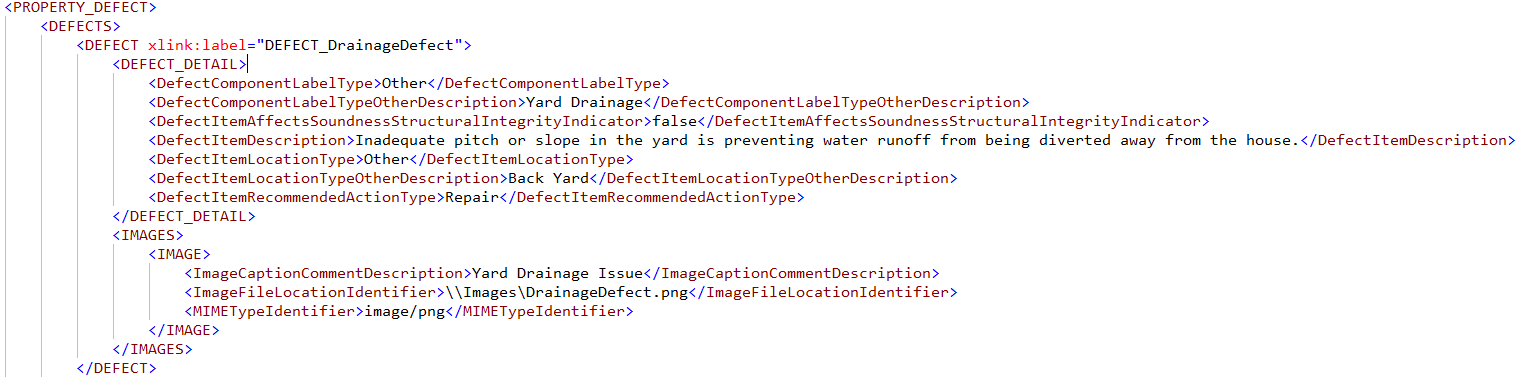
- Feature - Provide the value "Other" for DefectComponentLabelType (UID: 3900.0122, FID: Not on report) AND the text provided in DefectComponentLabelTypeOtherDescription (UID: 3900.0123, FID: 4.100|4.100.1) displays under the Feature column.
- Location - Provide the value "Other" for DefectItemLocationType (UID: 3900.0127, FID: Not on report) AND the text provided in DefectItemLocationTypeOtherDescription (UID: 3900.0159, FID: 4.101) displays under the Location column.
- Description - DefectItemDescription (UID: 3900.0125, FID: 4.102) always displays.
- Affects Soundness or Structural Integrity - DefectItemAffectsSoundnessStructuralIntegrityIndicator (UID: 3900.0124, FID: 4.103) always displays.
- Recommended Action - DefectItemRecommendedActionType (UID: 3900.0128, FID: 4.104)
- Each defect identified in this section must be associated with site. i.e., the DEFECT container must be linked to SITE container with an arcrole (for details see the Site - Arcrole Relationship section below).
Site Valuation Methodology#
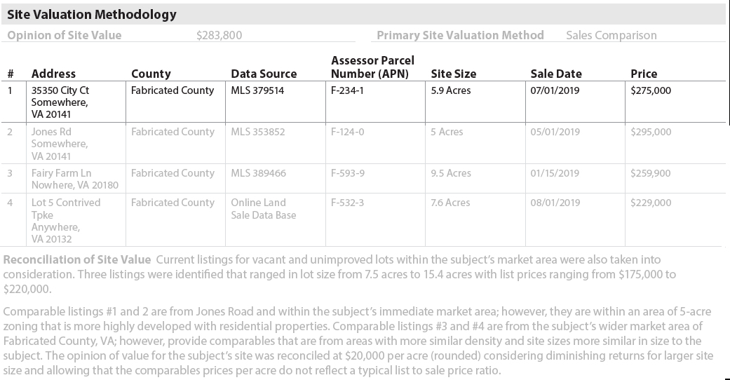
The Site Valuation Methodology subsection displays when (CostApproachIndicator = "false" AND SiteValueIndicator = "true"). (Figure 4 - 11)

- Opinion of Site Value - SiteEstimatedValueAmount (UID: 1100.0030, FID: 4.105) always displays when Site Valuation Methodology is included.
- Primary Site Valuation Method - SiteValuationMethodType (UID: 1100.0033, FID: 4.106) always displays when Site Valuation Methodology is included.
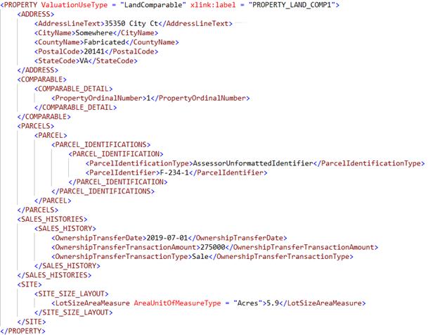
- When Primary Site Valuation Method - SiteValuationMethodType (UID: 1100.0033, FID: 4.106) = "SalesComparison" AND @ValuationUseType = "LandComparable", additional information is needed:
- Address or APN must be provided. If both are provided, both should be delivered in the data and displayed on the report.
- Address displays when Assessor Parcel Number (APN) - ParcelIdentifier (UID: 1100.0017, FID: 4.111) is null.
▪ # - PropertyOrdinalNumber (UID: 1100.0015, FID: 4.107)
▪ Address
- AddressLineText (UID: 1100.0005, FID: 4.108)
- CityName (UID: 1100.0007, FID: 4.108)
- PostalCode (UID: 1100.0009, FID: 4.108)
- StateCode (UID: 1100.0010, FID: 4.108) ▪ County - CountyName (UID: 1100.0008, FID: 4.109)
- Assessor Parcel Number (APN) displays when Address - AddressLineText (UID: 1100.0005, FID: 4.108) is null. ▪ Assessor Parcel Number (APN) - ParcelIdentifier (UID: 1100.0017, FID: 4.111)
- Address displays when Assessor Parcel Number (APN) - ParcelIdentifier (UID: 1100.0017, FID: 4.111) is null.
▪ # - PropertyOrdinalNumber (UID: 1100.0015, FID: 4.107)
▪ Address
- Data Source -DataSourceIdentifier (UID: 1800.0347, FID: 4.110)
- Displays when ((@ValuationUseType = "SalesComparable" OR "GrossRentMultiplierComparable" OR "RentalComparable" OR "LandComparable") AND DataSourceType = "MLS") OR
- Identifier, when provided, displays in the same cell as Data Source
- If there are multiple data sources, they display in the same cell separated by a "|" (e.g., MLS 123456 | Zoning)
- Displays when @ValuationUseType = "LandComparable"
- Follow display rules for LotSizeAreaMeasure (UID: 1500.0093, FID: 4.000)
- Display the number followed by @AreaUnitOfMeasureType
- Displays when @ValuationUseType = "LandComparable"
- Displays when @ValuationUseType = "LandComparable"
((@ValuationUseType = "SalesComparable" OR "GrossRentMultiplierComparable" OR "RentalComparable" OR "LandComparable") AND Exists)
Site Size - LotSizeAreaMeasure (UID: 1100.0020, FID: 4.112)
Sale Date - OwnershipTransferDate (UID: 1100.0018, FID: 4.113)
Price - OwnershipTransferTransactionAmount (UID: 1100.0019, FID: 4.114)
Reconciliation of Site Value - SiteEstimatedValueCommentDescription (UID: 1100.0031, FID: 4.115)
Displays when CostApproachIndicator (UID: 1000.0027, FID: Not on report) = "true" OR SiteValueIndicator (UID: 1000.0033, FID: Not on report) = "true".
Figure 4 - 11
Site Commentary#
The Site Commentary subsection displays only when comments are provided. Any commentary must use ValuationCommentText (UID: 0100.0044, FID: 4.116) and ValuationAnalysisCategoryType (UID: 0100.0045, FID: Not on report) = "Site".
Site Exhibits#
The Site Exhibits subsection displays when images are provided. All text displays above the image in bold font.
- Any images included must be delivered using ImageCategoryType (UID: 1400.0638, FID: 6.018).
- An image caption should be included using ImageCaptionCommentDescription (UID: 1400.0640, FID: 6.017).

Site Exhibits
| Report Field ID | Unique ID | MISMO Data Point/Enumerated Value | Image Header | Conditionality |
|---|---|---|---|---|
| 4.017.1 | 1400.0983 | ImageCategoryType/NonresidentialUse | Non-Residential Use | CR IF PropertyMixedUsageIndicator = "true" |
| 4.020.1 | 1400.0619 | ImageCategoryType/PropertyAccess | Property Access (Street Scene) | Required |
| 4.025.1 | 1400.0638 | ImageCategoryType/SiteInfluence | Site Influence | Display when image provided |
| 4.032.1 | 1400.0638 | ImageCategoryType/PermanentWaterfrontFeature | Permanent Waterfront Feature | Display when image provided |
| 4.034.1 | 1400.0638 | ImageCategoryType/WaterFrontage | Water Frontage | Display when PrivateAccessIndicator= "true" |
| 4.039.1 | 1400.0638 | ImageCategoryType/View | View | Display when image provided |
| 4.059.1 | 1400.0638 | ImageCategoryType/Encroachment | Encroachment | Display when image provided |
| 4.063.1 | 1400.0638 | ImageCategoryType/SiteCharacteristic | Site Characteristic | Display when image provided |
| 4.117.1 | 1400.0638 | ImageCategoryType/SiteExhibit | user provided text only | Display when image provided |
| 4.118.1 | 1400.0638 | ImageCategoryType/LandComparableMap | Map of Land Comparables | Display when image provided |
| 4.119.1 | 1400.0638 | ImageCategoryType/PropertyBoundaries | Property Boundaries | Display when image provided |
| 4.100.1 | 3900.0123 | Images provided for Apparent Defects, Damages, Deficiencies (Site) must be delivered in the DEFECT container. | Apparent Defects, Damages, Deficiencies - followed by DefectComponentLabelTypeOtherDescription | Display when image provided |
| 4.100.2 | 1400.0922 | ImageCaptionCommentDescription | User provided text follows [Apparent Defects, Damages, Deficiencies - followed by DefectComponentLabelTypeOtherDescription] | Display when caption is provided |
| 4.017.2 4.020.2 4.025.2 4.032.2 4.034.2 4.039.2 4.059.2 4.063.2 4.217.2 |
1400.0640 | User provided text following any enumerated value from ImageCategoryType. |
Reference Key Concept - Image Data for detailed guidance on the various ways images are handled in the URAR.
Site - Arcrole Relationships#
Arcrole relationships, establishes "relationships" or linkages in the XML data file that may be visually obvious on the URAR Report. In the XML data, specific instances of data points or containers must be connected to properly represent the information.
- Containers or datapoints to be linked are identified using "xlink:label."
- The RELATIONSHIP container holds the xlink:arcrole, xlink:from, and xlink:to attributes that describe the data relationships.
DEFECT to SITE#
Each defect identified in this section must be associated with site. i.e., the DEFECT container must be linked to SITE container via arcrole. One RELATIONSHIP container is required for each defect associated with the site.
| Unique ID | Parent Container | MISMO Attribute Name | Supported Attribute Enumerations |
|---|---|---|---|
| 3900.0148 | RELATIONSHIP | @xlink:arcrole | urn:fdc:mismo.org:2009:residential/DEFECT ContainsDefectOf SITE |
| 3900.0149 | RELATIONSHIP | @xlink:from | DEFECT_n |
| 3900.0150 | RELATIONSHIP | @xlink:to | SITE_n |
| 3900.0143 | SITE | @xlink:label | SITE_n |
| 3900.0121 | DEFECT | @xlink:label | DEFECT_n |


Refer to the section Arcrole/Data Relationships in the MISMO XML Version 3.6 chapter for additional information.